


Introduction
Protected areas are considered to be the most effective strategy for protecting biodiversity (Chape et al., Reference Chape, Spalding and Jenkins2008), yet in many places urban development is an increasing threat to many formerly remote protected areas (Margules & Pressey, Reference Margules and Pressey2000), and conservation planning must now take into account trends in human settlement (Theobald et al., Reference Theobald, Hobbs, Bearly, Zack, Shenk and Riebsame2000). Urban space may compete simultaneously with biodiversity, forest cover, protected areas, agricultural space and food security (Ahrends et al., Reference Ahrends, Burgess, Milledge, Bulling, Fisher and Smart2010; DeFries et al., Reference DeFries, Rudel, Uriarte and Hansen2010; Smith et al., Reference Smith, Gregory, van Vuuren, Obersteiner, Havlik and Rounsevell2010; Gordon et al., Reference Gordon, Acevedo-Whitehouse, Altwegg, Garner, Gompper and Katzner2012), with 54% of the human population now living in urban areas (United Nations, 2014), and this may have a negative impact on protected areas.
Downgrading, downsizing and degazetting of protected areas is an increasing concern (downgrading is an increase in use of an existing protected area, downsizing a reduction in territory, and degazetting the complete elimination of the area's protected status; Mascia & Pailler, Reference Mascia and Pailler2011). Five hundred such cases have been recorded in 57 countries, with the main causes being attributed to industrial-scale resource extraction and development (Mascia et al., Reference Mascia, Pailler, Krithivasan, Roshchanka, Burns and Mlotha2014), often linked inextricably to the presence or development of urban areas. One-quarter of protected areas are within 17 km of a city, and this distance is decreasing. An estimated 8% of species categorized as threatened on the IUCN Red List are threatened by urbanization (McDonald et al., Reference McDonald, Kareiva and Forman2008), which is likely to have a greater negative effect on native species (Aronson et al., Reference Aronson, La Sorte, Nilon, Katti, Goddard and Lepczyk2014), and range-restricted species are more vulnerable when urban areas comprise part of their range (McDonald et al., Reference McDonald, Kareiva and Forman2008). Furthermore, urban areas are growing faster in biodiverse coastal zones and hotspots (Elmqvist et al., Reference Elmqvist, Fragkias, Goodness, Güneralp, Marcotullio and McDonald2013). Maintaining effective protection, especially for threatened species, is best done through protected areas (Joppa & Pfaff, Reference Joppa and Pfaff2009), the main role of which is to separate biological resources from their threats (Margules & Pressey, Reference Margules and Pressey2000). Few studies have focused on the impacts of urbanization on protected areas in Africa, Asia and Latin America (Magle et al., Reference Magle, Hunt, Vernon and Crooks2012), or on the permanence of protected areas under increasing pressure from urbanization.
In Gabon 11% of land is protected by a network of National Parks (République Gabonaise, 2007), and in 2014 there was a governmental commitment to protect marine areas. With a low human population density (5.8 people per km2), urbanization presents a low level of threat to the overall protected area network. It is a growing concern in areas of urban development, however, such as the capital city, Libreville, where peri-urban expansion is encroaching upon two nearby National Parks and a Forest Reserve. Here, a rare case of protected area downgrading, downsizing and degazetting has been observed (sensu Mascia et al., Reference Mascia, Pailler, Krithivasan, Roshchanka, Burns and Mlotha2014): a Forest Reserve was downsized gradually over a period of 80 years, and by 2010 its future was under threat. Several strictly endemic plant species were thought to be present in the area but there was a lack of information about their conservation status and distribution. Here we describe how the assessment of endemic species was used to improve the delimitation of a protected area and prevent further downgrading, downsizing and degazetting, using the following steps: refinement of the endemic species list; assessment of threats to habitat; evaluation of the species, using the criteria for the IUCN Red List of Threatened Species; identification of key conservation sites; delimitation of a new protected area using these datasets; and application of ex situ conservation techniques.
Study area and conservation context
Coastal Gabon is part of the Guineo–Congolian centre of endemism for plants (White, Reference White1983). The rate of plant endemism in Gabon is 11–13% (Sosef et al., Reference Sosef, Wieringa, Jongkind, Achoundong, Issembe and Bedigian2006), higher than in neighbouring countries (Lachenaud, Reference Lachenaud2009; Onana, Reference Onana, van der Burgt and van der Maesen2010). Floristic richness has been underestimated for coastal areas (Dauby et al., Reference Dauby, Leal and Stévart2008; Harris et al., Reference Harris, Armstrong, Walters, Wilks, Mouandza Mbembo and Niangadouma2012), where the flora is distinct from that of the adjacent mountainous areas (Dauby et al., Reference Dauby, Hardy, Leal, Breteler and Stévart2014).
Urban coastal areas are subject to intense migration, with Gabon's rate of urbanization at 87%, the highest in Africa (United Nations, 2014). In Central Africa rural residents migrate to peri-urban and urban areas to find employment, while also maintaining subsistence activities (Trefon, Reference Trefon, Reed and Barnes2003; East et al., Reference East, Kümpel, Milner-Gulland and Rowcliffe2005; Omasombo, Reference Omasombo, Simone and Abouhani2005; Socpa, Reference Socpa2010).
The Mondah forest is on the Libreville peninsula, c. 21 km north of the centre of Libreville (Fig. 1). The Mondah area receives 3,000–3,500 mm of rainfall per year, with a mean temperature of 25°C and a dry season during June–September (Vande Weghe, Reference Vande Weghe2005). The area is characterized by valleys and rivers, often creating hyper humid climates and diverse vegetation types. This ecosystem extends between the Libreville peninsula and across the Corisco Bay into Equatorial Guinea's Rio Muni. The Mondah forest has been inhabited at least since 3400 BP (Clist, Reference Clist2005) and commercially exploited for forest resources (dyewoods and salt) at least since the 1400s (Patterson, Reference Patterson1975); timber exploitation began in the late 1800s (Quilliard, Reference Quilliard1920; Meye, Reference Meye1969). In the 1960s six ethnic groups resided there (Deschamps, Reference Deschamps1962) but as a result of recent immigration the forest now supports 24 ethnic groups (Ikabanga, Reference Ikabanga2011). People use this peri-urban forest for subsistence farming, charcoal production, artisanal logging, sand extraction (Trefon, Reference Trefon, Reed and Barnes2003) and traditional medicine (Delhotal, Reference Delhotal2009; Koumba-Madingou, Reference Koumba-Madingou2009), with a noticeable difference in the resource usage of rural and urban people. The Forêt Classée de la Mondah was created in 1934 by the colonial French administration as a timber production forest and research area (including for establishing plantations of Aucoumea klaineana, a subendemic timber species), and from 1951 was managed by the National Forestry School. The management objectives for the forest were based on production of A. klaineana, and research into the species. Later, the forest was used by the National Forestry School for educational purposes. Only in the 1990s was the role of the area in protecting biodiversity highlighted (Wilks, Reference Wilks1990). Until the start of this study the forest had been under the jurisdiction of the National Forestry School but in 2010 there was a proposed change in administration, giving management responsibility to Gabon's National Parks Agency, and downsizing of the protected area was proposed.
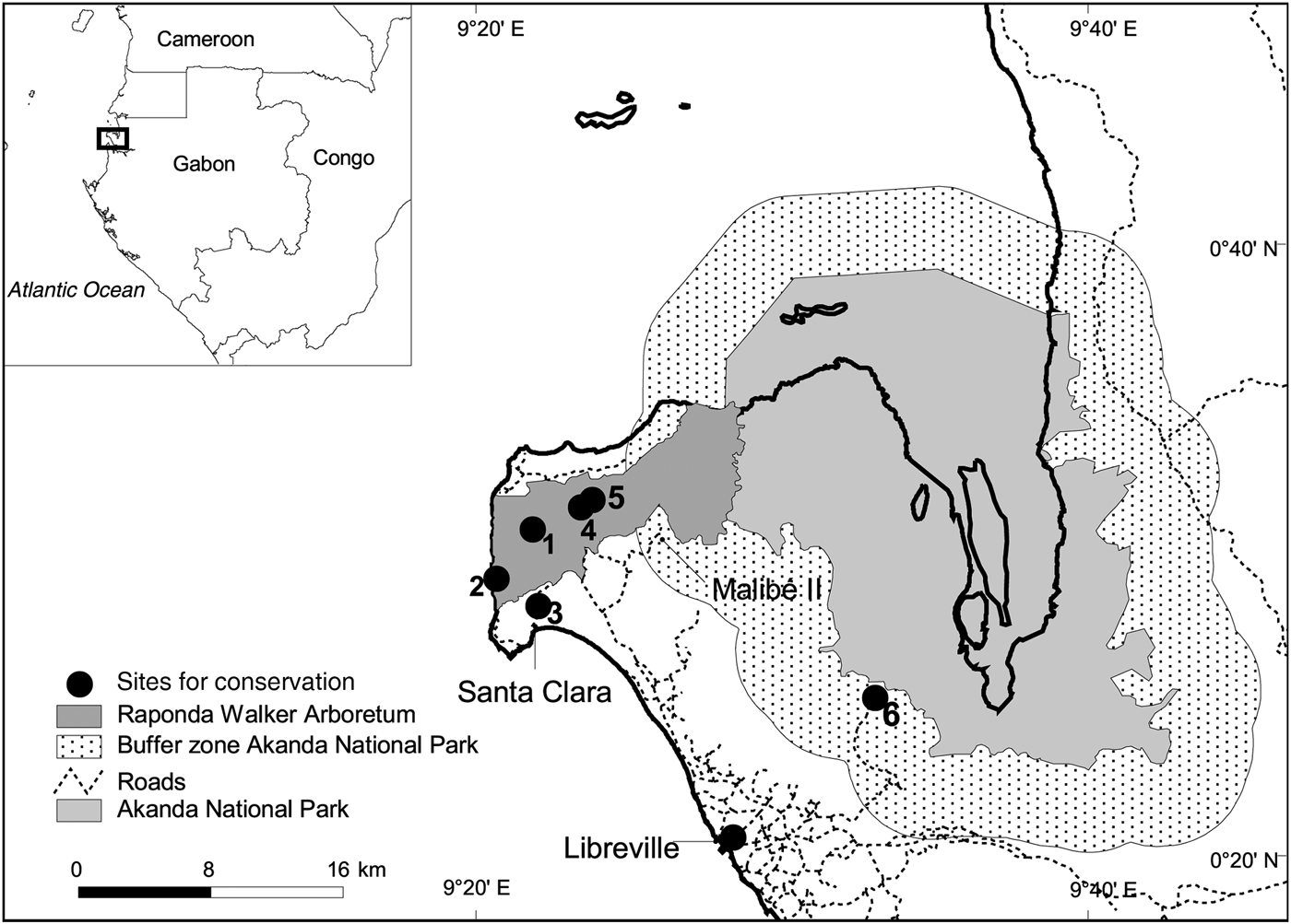
Fig. 1 The Raponda Walker Aboretum on the Libreville peninsula, Gabon. Numbers denote important sites for conservation (Table 2).
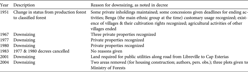
Originally the protected area comprised 12,400 ha (Ministère des Eaux et Forêts, 1997) but a series of legislative changes during 1951–2004 successively reduced it to < 5,000 ha by 2004 (Figs 2 & 3). There were various reasons for the downsizing, including the according of private inholdings and construction of public utilities; however, the 2004 downsizing, which four of the authors observed, was predominantly to convert land for housing in the southern portion (where 2,000 ha were lost; Table 1). Degradation of the forest has been noted since 1970, when it was attributed to sand extraction, agricultural activities and the creation of villages near forestry camps (Ministère des Eaux et Forêts, 1997). Although in the past the Forêt Classée de la Mondah had been subject to disturbance through resource extraction and plantation establishment, some forest recovery seemed likely. However, during 1960–2000 55% of the forest was transformed into secondary forest (Nziengui et al., Reference Nziengui, Nana, Oslisly, Tchindjan, Mapaga and Ropivia2008), making the Mondah likely to be an Endangered ecosystem according to IUCN criteria for the Red List of Ecosystems (Keith et al., Reference Keith, Rodríguez, Rodríguez-Clark, Nicholson, Aapala and Alonso2013). Although the rate of deforestation in Gabon is low overall (< 1% per year; COMIFAC, 2010), mapping shows the highest level of deforestation occurs in the Mondah area (Hansen et al., Reference Hansen, Potapov, Moore, Hancher, Turubanova and Tyukavina2013).

Fig. 2 The boundaries of Forêt Classée de la Mondah in 1951 (a), 1967 (b), 1977 (c), 1983 (d), 2004 (e), and 2012 (f), when the protected area was renamed the Raponda Walker Arboretum.

Fig. 3 History of downsizing of Forêt Classée de la Mondah in Gabon (Fig. 1) during 1934–2012. The protected area originally covered 12,400 ha (Ministère des Eaux et Forêt, 1997) but was reduced by successive declassifications in 1951 (Afrique Equatoriale Française, 1951), 1967 (République Gabonaise, 1967), 1977 and 1980 (which were reversed in 1983; République Gabonaise, 1983), 2001 (République Gabonaise, 2001) and 2004 (République Gabonaise, 2004). In 2012 the area was increased to 6,747 ha; the dashed line indicates the proposed reduction to 1,318 ha.
Table 1 History of downsizing of the Mondah forest, Gabon (Fig. 3), as reported in government decrees.
By 2010 the situation was critical. Not only had most of the previously downsized forest been cleared for peri-urban land use, but increasing human activity was encroaching upon the remaining protected area, and management capacity was inadequate. The city had expanded such that its outer edge was within 5 km of the forest, and the forest was becoming increasingly degraded. At this time the National Parks Agency put forward a proposal to take over management of the forest under newly defined limits. A draft decree proposed the creation of a National Park comprising a terrestrial zone (henceforth the Centre; 1,318 ha) and marine zones (1,610 ha) surrounded by a buffer zone (5,715 ha). The proposed limits were based on earlier plans to target protection efforts on a core area of intact forest, allowing controlled development in the degraded surrounding areas, under buffer zone management policies (Wilks, Reference Wilks1990). However, it was not clear how the buffer zone would be managed or if there were endemic plant species in the forest outside the Centre. The National Parks Agency was willing to extend the boundaries of the proposed protected area if evidence of threatened or endemic species was provided.
Although originally the Mondah forest was considered to be of local interest only (Doumenge et al., Reference Doumenge, Ndinga, Nembot, Tchanou, Ondo and Nze2003), it was suspected to contain c. 50 restricted-range plant species endemic to the Libreville Peninsula, some of them extending to the adjacent Corsico Bay area in Equatorial Guinea, and some of which were in the process of being described (Kenfack, Reference Kenfack2011; Breteler, Reference Breteler2012; Lachenaud et al., Reference Lachenaud, Stévart, Ikabanga, Ndjabounda and Walters2013b). Only two species had been evaluated using the IUCN Red List criteria (IUCN, 2013) and thus the conservation status of most of the species was unknown. To inform the process of boundary delimitation for the new protected area, evidence of subpopulations of restricted-range species needed to be provided to the National Parks Agency, along with an assessment of their irreplaceability (i.e. whether the habitat is conserved elsewhere) and vulnerability (i.e. the risk of the area being transformed to other land uses; Margules & Pressey, Reference Margules and Pressey2000).
Given the risk of extinction of endemic species, ex situ conservation was considered as a solution in the event of downsizing, if endemic species were found outside the reduced protected area. Ex situ conservation techniques, or cultivation of species outside their native habitats, can help to ensure that threatened species are maintained (Müller & Eriksson, Reference Müller and Eriksson2013), particularly when the habitats are so threatened that the species are at risk of extinction.
Methods
Refinement of the list of endemic plant species
A list of endemic plant species in the Libreville area was compiled through searches of herbarium records, botanical literature (e.g. Sosef et al., Reference Sosef, Wieringa, Jongkind, Achoundong, Issembe and Bedigian2006) and the database of Naturalis Biodiversity Center in the Netherlands. For each species, information on family, habitat, collection dates and localities, distinctive identification criteria, and phenology was compiled from botanical journals and type specimens. Many specimens had imprecise records of localities, making relocation difficult. During January–April 2011 fieldwork was conducted at known species localities and in areas or habitats where endemic species were thought to occur. Four of the authors (GW, OH, DI, ENN) were living on site and worked in the forest daily. Others (OL, TS) specialized in Rubiaceae and Orchidaceae visited the site occasionally, and thus the knowledge of these species and associated success in finding subpopulations was increased. When new subpopulations were discovered, herbarium collections were made and locations were recorded using a global positioning system.
Species threat assessment
The study focused on two villages at the southern boundary of the Mondah forest: Santa Clara and Malibé II. These villages are situated between the Mondah forest and Libreville and have been subject to urbanization, migration and development. To understand the threats to habitat and species use, participant observation (residing in the communities) and interviews were conducted in Santa Clara during 2005–2011, with follow-up visits during 2012–2013. Interviews were conducted in c. 25 randomly chosen households in each village during January–April 2011 to understand the presence and use of both endemic and non-endemic plants in terms of species, category of usage, and utilization of forest space. The questionnaire, which was inspired by other methodologies (e.g. McClatchey et al., Reference McClatchey, Thaman, Juvik, Mueller-Dombois, Bridges and Daehler2004), was tested for clarity in a nearby village. After each interview the informant showed the interviewer the plants that had been discussed, and these were collected as herbarium specimens. The specimens were identified, and uses of endemic species were noted. A portable herbarium of the endemic species was presented to informants that were particularly knowledgeable about forest use, to inquire if they knew the species. The results of this ethnobotanical study are reported in detail in Ikabanga (Reference Ikabanga2011).
Assessing the species using IUCN Red List criteria
Species were evaluated using the IUCN categories and criteria (IUCN Standards and Petitions Subcommittee, 2013). Maps, produced in ArcView v. 3.1 (ESRI, Redlands, USA), were plotted to calculate the Area of Occurrence and Extent of Occurrence for all endemic plant species in the Mondah forest, and the number of localities was determined. Species were then evaluated, and assessments were submitted to IUCN using the Species Information System tool (IUCN Species Information Service 2.0, 2015).
Ex situ conservation
When subpopulations were discovered the area was revisited to procure samples for ex situ conservation trials in Sibang Arboretum and at Jardi-Gab, Libreville. Soil was transported from the sample sites for all trials, and seeds, cuttings and direct transplants were used when possible.
Delimiting the new protected area
Species distributions were mapped and threats were categorized based on field observations, interviews and literature. Using the principles of irreplaceability and vulnerability, species conservation priorities were assessed based on the overlap between the proposed protected area and the distributions of the endemic species. Recommendations and data were provided to the National Parks Agency and contributed to the definition of the new boundary of the protected area.
Results
Endemic species, mapping distributions, and evaluations
Of the 50 species that were hypothesized as endemic to the Libreville peninsula, 24 were verified (Lachenaud et al., Reference Lachenaud, Stévart, Ikabanga, Ndjabounda and Walters2013b), the others being rejected because records were found outside the study area, or because of revised taxonomy or uncertain identification. Additional subpopulations of nine of these 24 species were identified during fieldwork.
Six sites of conservation importance (e.g. sites containing important subpopulations of endemic species) were found. The majority were located in the Mondah forest but were not restricted to the Centre (Table 2, Fig. 1). The site in the Akanda National Park buffer zone is noteworthy because of the unique presence of Aristogeitonia gabonica. Of the 24 endemic species, seven were not evaluated using the IUCN categories and criteria (undescribed species were not evaluated, as recommended in the Red Listing standards, and the other species were added after the fieldwork concluded, and therefore data were too limited for their assessment), three were categorized as Data Deficient, two as Vulnerable, six as Critically Endangered, and six as Endangered; three of the Critically Endangered species may be extinct (Table 3). Two species that were categorized as Vulnerable in the late 1990s (Dactyladenia laevis and Jollydora pierrei) were again categorized as Vulnerable in the reassessments. Historical information on former distributions was difficult to ascertain because localities recorded for older botanical specimens were imprecise. If historic localities had been more precise, demonstrating the reduction of species distribution over time would have been used as part of the evaluation criteria selected from the IUCN standards.
Table 2 Important sites for conservation in and around the Mondah forest, Gabon (Fig. 1), with endemic species present, and habitat type.
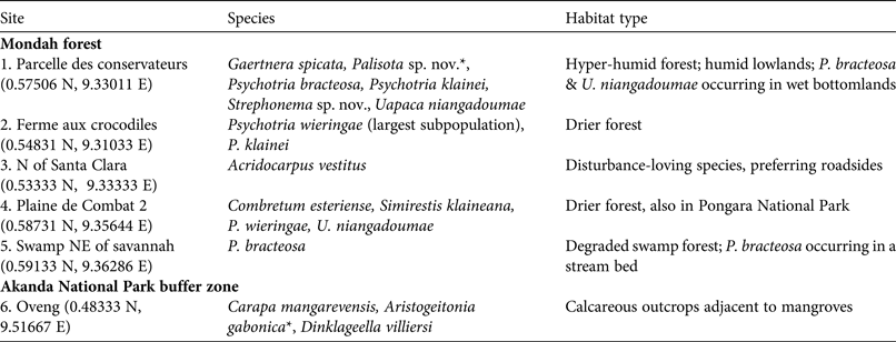
* Species occurs uniquely at this site
Table 3 Red List categories of 24 endemic species in the Mondah forest, Gabon (Fig. 1), evaluated using IUCN criteria, with the number of locations where each species has been found, and the species’ distribution.

1 CR(PE), Critically Endangered (Possibly Extinct); CR, Critically Endangered; DD, Data Deficient; EN, Endangered; NE, Not Evaluated; VU, Vulnerable
2 Libreville peninsula includes Parc National de Pongara; Mondah forest includes the western buffer zone of Parc National d'Akanda; Rio Muni is in Equatorial Guinea
Ex situ conservation trials
In the ex situ conservation trials, all attempts to cultivate using seeds and cuttings failed. Only transplants were successful, and these only in the cases of Psychotria bracteosa, Psychotria klainei, Psychotria wieringae, A. gabonica and Dinklageella villiersii. This is unsurprising because tropical seeds are typically difficult to germinate and often are only viable for a few days (Baskin & Baskin, Reference Baskin and Baskin1998). Increased success with cuttings could be possible with the use of a growth hormone.
Threats to habitat and species
In the 377 herbarium specimens collected for the ethnobotanical study 116 species were identified; none were endemic. No informants, including traditional healers who use the forest flora in their pharmacopeia, were able to indicate additional subpopulations when presented with specimens of endemic plants.
Most habitat uses, such as charcoal production, agriculture, sand production, and traditional medicine, occurred on the forest border and not within the protected area. Most of these activities were using habitat that could have been occupied by endemic species and had previously been part of the protected area.
The following IUCN threat categories were identified: residential & commercial development, agriculture & aquaculture, energy production and mining, and biological resource use. Urbanization was identified as a threat to all the species evaluated, and swidden agriculture, sand exploitation and artisanal logging were identified as threats in 88% of cases. The main exceptions were the three species (Carapa mangarevensis, D. villiersi, A. gabonica) in the adjacent mangrove habitat characterized by calcareous outcrops, where agriculture, charcoal production and sand exploitation were not evident.
Many informants discussed their use of the forest for ceremonies, and we encountered several ceremonial sites during the study. Some traditional healers regretted the loss of sites as a result of past declassification of the protected area, and noted that the forest was an important cultural resource for them and their clients.
Delimiting the new boundaries
Species distributions were mapped over the proposed 2010 protected area boundaries. The 24 endemic species assessed were represented in the Mondah forest or in its environs. For 10 strictly endemic species, the global distributions were largely limited to the Mondah forest but not restricted to the Centre. For these species the 2010 proposal would have provided insufficient protection for the majority of their range, and therefore the habitat in the wider Mondah forest was considered to be irreplaceable. All of the species were threatened by urbanization and many were categorized as Endangered or Critically Endangered. As such, these species and their habitats fulfilled both the irreplaceability and vulnerability criteria to be considered a conservation priority (Margules & Pressey, Reference Margules and Pressey2000).
Based on the distribution of the endemic species it was recommended to the National Parks Agency that they maintain the original protected area boundaries rather than the proposed, reduced boundaries, to facilitate conservation of all threatened species. After the mapping of the endemic species was completed we provided data to the National Parks Agency, and assisted in mapping the limits to ensure that the maximum area was protected around endemic subpopulations. The Centre was delimited as the core area, surrounded by a zone where limited development could occur. Additionally, a habitat corridor was created to Akanda National Park. Had the 2010 proposal been accepted the protected area would have been downsized, but instead the area was increased to 6,747 ha. Although the protected area is smaller than the 12,400 ha declared in 1934, the 2012 adjustment succeeded in reversing a trend of continual downsizing.
The declaration was signed into law in October 2012, with the protected area intended to serve the purposes of biodiversity protection, tourism, environmental education, and leisure (République Gabonaise, 2012). The area was renamed the Raponda Walker Arboretum, after the Gabonese ethnobotanist André Raponda Walker, who documented ethnobotany, linguistics and ceremonial rites throughout Gabon (Raponda Walker & Sillans, Reference Raponda Walker and Sillans1961, Reference Raponda Walker and Sillans1962).
Discussion
Evaluating endemic species in the context of the protected area boundaries facilitated an assessment of irreplaceability. The threat assessment revealed that the plant populations were vulnerable to land conversion, and without this information there would have been little justification to avoid reducing the protected area. Given the uniqueness of the endemic flora of the Libreville peninsula, even when compared to adjacent areas (Dauby et al., Reference Dauby, Hardy, Leal, Breteler and Stévart2014), and the current rate of land conversion, without a protected area there would be little chance for the survival of this ecosystem. The transition in management of the area to the National Parks Agency suggests that the area will be managed effectively, including ensuring protection of species. Management plans are under development and include work related to the threatened flora.
Protected area downgrading, downsizing and degazetting is rare in Gabon but it is difficult to avoid completely in urban contexts. Here, the demonstrated presence of endemic species motivated the government to maintain the limits of the protected area, but this is not always the case, even in non-urban situations. In Australia, despite scientific evidence of the presence of endemic species, the government intends to authorize logging in reserves in Victoria (Lindenmayer & Possingham, Reference Lindenmayer and Possingham2013). In other cases agribusiness development takes priority, as in the case of the degazettement of forest reserves in Uganda (Mwavu & Witkowski, Reference Mwavu and Witkowski2008) or the proposed degazettement of Gambella National Park in Ethiopia, despite the presence of endemic fauna (Pearce, Reference Pearce2011). In yet other cases, even where endemics are known to occur and are under pressure from urbanization, there are no protected areas, as is the case near Yaoundé, Cameroon (Simo et al., Reference Simo, Droissart, Sonké and Stévart2009; Lachenaud et al., Reference Lachenaud, Droissart, Dessein, Stévart, Simo and Lemaire2013a); development in and around protected areas along the coast of Cameroon is having a negative impact on the endemic flora (Tchouto et al., Reference Tchouto, Yemefack, de Boer, de Wilde, van der Maesen and Cleef2006).
Many cases of protected area downgrading, downsizing and degazetting are unrecorded (Mascia & Pailler, Reference Mascia and Pailler2011), and although urbanization does not appear to be a major threat, recent cases have involved the degradation of forest reserves outside Dar es Salaam as a result of charcoal production (Ahrends et al., Reference Ahrends, Burgess, Milledge, Bulling, Fisher and Smart2010) and deforestation in Freetown's peri-urban Western Area Peninsula Forest Reserve (Munro, Reference Munro2009). Some urban protected areas threatened by development have been saved as a result of activism, such as Nairobi's Uhuru Park (Maathai & Antinori, Reference Maathai and Antinori2001). In other cases, more land is needed to save endemic species or ecosystems, and agreements with existing landowners are required, as in Capetown (Rebelo et al., Reference Rebelo, Holmes, Dorse and Wood2011).
Many protected area systems were not created originally for biodiversity conservation (Joppa & Pfaff, Reference Joppa and Pfaff2009) but there is a trend towards systematic conservation planning and cost and management efficiency (Fuller et al., Reference Fuller, McDonald-Madden, Wilson, Carwardine, Grantham and Watson2010). Analyses of species and habitat protection are now used to set conservation priorities for the creation of protected areas (Callmander et al., Reference Callmander, Schatz, Lowry, Laivao, Raharimampionona and Andriambololonera2007; Gereau et al., Reference Gereau, Luke, Kindeketa, Bodine, Schatz, van der Burgt and van der Maesen2010; Clausnitzer et al., Reference Clausnitzer, Dijkstra, Koch, Boudot, Darwall and Kipping2012; Holland et al., Reference Holland, Darwall and Smith2012), using a variety of approaches such as key biodiversity area assessments, and Red List assessment of threatened species (Schatz, Reference Schatz2009) and ecosystems. However, few of the recommendations from these studies seem to be put into practice by state administrations (Brooks et al., Reference Brooks, Balmford, Burgess, Fjeldså, Hansen and Moore2001). Conservation analyses sometimes reveal that existing protected areas harbour threatened species (e.g. Safi et al., Reference Safi, Armour-Marshall, Baillie and Isaac2013); however, using species distributions to inform the delimitation of new protected area boundaries is rare. There is a significant difference between the processes used in the prescription and application of conservation proposals (Margules & Pressey, Reference Margules and Pressey2000). Here we report on the implementation of one such proposal, which led to the avoidance of downgrading, downsizing and degazetting of a protected area.
Although the reasons for downsizing the protected area in the Mondah forest varied over the years, the downsizing in 2004 was a response to changes in land use. Whereas protected area downgrading, downsizing and degazetting may accelerate deforestation (Forrest et al., Reference Forrest, Mascia, Pailler, Zuraidah Abidin, Araujo, Krithivasan and Riveros2015), the effects of historical downsizing are less clear. The 2004 downsizing event was a result of urbanization, and the threat of urbanization to all the species assessed shows how downsizing can threaten biodiversity.
The survival of endemic plant species in the Mondah forest despite modern habitat reduction and historical forest use is striking. Gaertnera spicata was first collected in the 1800s in present-day Sibang Arboretum, 8 km east of Libreville and now part of the city; today, the species remains only in the Centre, in a rare micro-habitat. Although none of the endemic species were used directly by people, all were threatened indirectly by habitat conversion. In areas where habitat diversity is high, it appears threatened species may persist in microhabitats under conditions of rapid land conversion. After more than a century of botanical research new species continue to be found in the Mondah forest. In addition to the three species for which descriptions were published recently (Kenfack, Reference Kenfack2011; Breteler, Reference Breteler2012; Lachenaud et al., Reference Lachenaud, Stévart, Ikabanga, Ndjabounda and Walters2013b), others remain undescribed, a phenomenon typical of countries with limited botanical inventories (Campbell & Hammond, Reference Campbell and Hammond1989).
Despite the existing herbarium specimen information, which can indicate a species’ distribution, there is a lack of confirmation of the specific location of many subpopulations, particularly for species categorized as Data Deficient or for those that were Not Evaluated. More work is needed to expand ex situ conservation, such as disseminating propagules of these rare species in public gardens as part of an environmental education programme, contributing to efforts underway in the Raponda Walker Arboretum. Two species in particular (A. vestitus and G. spicata) have high ornamental value.
Protected areas, particularly in urban areas, supply a range of human needs. The Raponda Walker Arboretum is simultaneously a critical habitat for endemic species and a religious–cultural space, the Mondah being one of the closest forests to Libreville and one of the most accessible. The creation of the Arboretum is an exemplary step in protecting irreplaceable habitats of rare species while providing forest for cultural activities, environmental education, and leisure.
Acknowledgements
We thank John Mitchell and the Beneficia Foundation for believing in this project. This project supported two MSc theses at the Université des Sciences et Techniques de Masuku. All researchers were hosted by IPHAMETRA (the Institute of Pharmacopeia and of Traditional Medicine). Administrative assistance was provided by the Wildlife Conservation Society–Gabon. Research permission was obtained from the Centre National de la Recherché Scientifique et Technique, École Nationale des Eaux et Forêts and the Gabon National Parks Agency. Field assistance was provided by E. Augowet Bonguno, S. Dessein, P. Christy, J-N. Boussiengui, L. Moungoudy, P. Koumba Ipandi, J.R. Ondzaghe and B. Bouligui. P. Christy found the decrees for the declassification. The residents of Santa Clara and Malibé II welcomed us warmly and granted access. The following herbaria gave us access to their collections: LBV, BR, BRLU and WAG. OL was a research fellow of the Fonds National de la Recherche Scientifique. This paper benefited from comments by N. Burgess, S. Regnaut, R. Gereau, M. Lee and an anonymous reviewer. We are grateful to Martin Fisher for his work in finalizing the maps for Figure 3.
Biographical sketches
Gretchen Walters works in Central Africa on plant diversity, fire management, and human dimensions of conservation. Eddy Ngagnia works on floristics. Davy Ikabanga researches the genetics of tropical trees. Jean-Phillipe Biteau focuses on cultivating native species from Gabon. Olivier Hymas works on the human dimension of conservation in light of environmental history. L.J.T. White directs Gabon's National Parks and focuses on biodiversity conservation. Anne-Marie Ndong Obiang is the Conservator of the Raponda Walker Arboretum. Parfait Ndong Ondo is the National Parks Agency's geographical information system specialist. Kathryn Jeffery works on primates, fire and management and is the Scientific Advisor to the National Parks Agency. Olivier Lachenaud studies plant diversity in the tropics, focusing on the Rubiaceae. Tariq Stévart studies plant diversity and conservation in Africa, focusing on orchids.


