


INTRODUCTION
Forests support the provision of many ecosystem services, including the protection of hydrological flows and maintenance of water quality, protection of soil, climate regulation through carbon sequestration and storage, and the conservation of biodiversity (Daily et al. Reference Daily, Alexander, Ehrlich, Goulder, Lubchenco, Matson, Mooney, Postel, Schneider and Tilman1997; Nasi et al. Reference Nasi, Wunder and Campos2002; Grimaldi et al. Reference Grimaldi, Oszwald, Dolédec, Hurtado, Miranda, Sartre, Assis, Castañeda, Desjardins, Dubs, Guevara, Gond, Lima, Marichal, Michelotti, Mitja, Noronha, Oliveira, Ramirez, Rodriguez, Sarrazin, Jr, Costa, Souza, Veiga, Velasquez and Lavelle2014). Yet, c. 13 million hectares of the world's forests were lost each year over the last decade (FAO [Food and Agriculture Organization of the United Nations] 2010), mainly due to conversion for cattle ranching and agriculture (Margulis Reference Margulis2003; FAO 2010). Between 2000 and 2010, Brazil alone contributed to 44% of the global net loss of forest, most of which can be attributed to deforestation in the Amazon (FAO 2010; Barreto & Araújo Reference Barreto and Araújo2012). However, Brazil has also shown the largest decline in annual forest loss over the past decade, primarily owing to a marked drop in Amazonian deforestation since 2005 (Hansen et al. Reference Hansen, Potapov, Moore, Hancher, Turubanova, Tyukavina, Thau, Stehman, Goetz, Loveland, Kommareddy, Egorov, Chini, Justice and Townshend2013).
In attempting to protect forests from clearance and degradation, the Brazilian government has created forest protected areas on both public and private land (Chape et al. Reference Chape, Harrison, Spalding and Lysenko2005; Schmitt et al. Reference Schmitt, Burgess, Coad, Belokurov, Besançon, Boisrobert, Campbell, Fish, Gliddon, Humphries, Kapos, Loucks, Lysenko, Miles, Mills, Minnemeyer, Pistorius, Ravilious, Steininger and Winkel2009; Veríssimo et al. Reference Veríssimo, Alicia, Maior, Monteiro, Brito, Souza, Augusto, Cardoso, Conrado, Araújo, Fany, Ribeiro, Lima, Ribeiro, Vedoveto, Mesquita, Barreto, Salomão and Futada2011). Approximately 46% of the Brazilian Amazon was under some form of public protection in 2012 (A. Rolla, Brazilian Socioenvironmental Institute/Instituto Socioambiental [ISA], personal communication 2012)., However, public protected areas alone are likely to be inadequate in ensuring either the protection of biodiversity or the maintenance of critical ecosystem services, many of which depend upon the conservation of areas of forest across entire landscapes, and not on isolated protected areas (Silva Dias et al. Reference Silva Dias, Rutledge, Kabat, Silva Dias, Nobre, Fish, Dolmam, Zipser, Garstang and Manzi2002; Soares-Filho et al. Reference Soares-Filho, Nepstad, Curran, Cerqueira, Garcia, Ramos, Voll, McDonald, Lefebvre and Schlesinger2006). For example, protected areas can be less effective at conserving hydrological catchments then preventing deforestation, as headwaters can be located outside protected area boundaries (Soares-Filho et al. Reference Soares-Filho, Nepstad, Curran, Cerqueira, Garcia, Ramos, Voll, McDonald, Lefebvre and Schlesinger2006). Instead, networks of public and private protected areas, supported by strategic ecological–economic zoning plans, are needed to ensure the maintenance of locally and regionally relevant ecosystem services, as well as maintain habitat connectivity, ensure population viability in more isolated forest remnants and facilitate species migrations (Peres et al. Reference Peres, Gardner, Barlow, Zuanon, Michalski, Lees, Vieira, Moreira and Feeley2010).
The conservation of forests in private lands is therefore a vital part of any overall conservation strategy for the Amazon (Soares-Filho et al. Reference Soares-Filho, Nepstad, Curran, Cerqueira, Garcia, Ramos, Voll, McDonald, Lefebvre and Schlesinger2006; Lees & Peres Reference Lees and Peres2008; Peres et al. Reference Peres, Gardner, Barlow, Zuanon, Michalski, Lees, Vieira, Moreira and Feeley2010; Ferreira et al. Reference Ferreira, Pardini, Metzger, Fonseca, Pompeu, Sparovek and Louzada2012). Although uncertainties about land tenure (such as land ownership rights and location of properties) make it difficult to conduct a comprehensive assessment of land cover change on private lands (Barreto et al. Reference Barreto, Pinto, Brito and Hayashi2008; Brito & Barreto Reference Brito and Barreto2011), current estimates suggest they hold c. 60% of the remaining native vegetation in Brazil as a whole (Ferreira et al. Reference Ferreira, Pardini, Metzger, Fonseca, Pompeu, Sparovek and Louzada2012; Soares-Filho Reference Soares-Filho2013).
The protection of riparian forests is of particular importance in private lands as they help maintain the provision of key ecosystem services, such as the prevention of soil erosion in agricultural systems, the maintenance of water flows and water quality, and the conservation of biodiversity and ecological connectivity (Rodrigues & Gandolfi Reference Rodrigues, Gandolfi, Rodrigues, de Freitas Leitão Filho, Lima and Kon2000; Lees & Peres Reference Lees and Peres2008; Castello et al. Reference Castello, McGrath, Hess, Coe, Lefebvre, Petry, Macedo, Renó and Arantes2013; Grimaldi et al. Reference Grimaldi, Oszwald, Dolédec, Hurtado, Miranda, Sartre, Assis, Castañeda, Desjardins, Dubs, Guevara, Gond, Lima, Marichal, Michelotti, Mitja, Noronha, Oliveira, Ramirez, Rodriguez, Sarrazin, Jr, Costa, Souza, Veiga, Velasquez and Lavelle2014). Their importance is often recognized in environmental legislation, with more restrictions preventing land-use change in riparian forests than in non-riparian forest areas in private properties (as is the case in Brazil under the 2012 federal Forest Code Law No. 12.651, see URL http://www.planalto.gov.br/ccivil_03/_ato2011-2014/2012/lei/l12.651.htm) (Sparovek et al. Reference Sparovek, Berndes, Klug and Barretto2010), as well as in other countries (for example Belize, Costa Rica, the USA and Australia). In Brazil, only low impact activities (such as ecotourism) are allowed in riparian areas (alongside other particularly sensitive areas such as springs, steep slopes and hilltops, jointly termed permanent preservation areas, and abbreviated to APPs in Portuguese). Whilst deforestation within APPs is only permitted in exceptional circumstances (for example for public projects), depending on the region, between 20 and 80% of the area outside APPs can be deforested in a given private property.
Despite their importance, the effectiveness of the legal protection afforded to riparian vegetation in APPs (hereafter termed RAPPs) in the Brazilian Amazon has been poorly assessed. There are at least three main reasons for this. First, although geographic information systems (GIS) and remote sensing products are essential for effective law enforcement (Firestone & Souza Reference Firestone and Souza2002), we are not aware of any studies that map water courses and examine land cover change in riparian and non-riparian vegetation over a decadal time-scale. Second, the difficulties of assessing the protection afforded by RAPPs have been exacerbated by a long period of regulatory confusion and uncertainty surrounding the definition of the Brazilian Forest Code, which lasted until the revised law came into force in October 2012 (Garcia Reference Garcia2012). Third, assessing the extent of legal liabilities (such as deficit of RAPP in a given private property compared to what is required by law) depends upon access to an accurate georeferenced register of private properties. However, less than ten Brazilian states have initiated the registration of their private properties in the government database (the Environmental Rural Property Register, abbreviated to CAR in Portuguese), and, of these, the Amazonian states of Pará and Mato Grosso States are the most advanced. Nevertheless, only 10% of the 144 municipalities in Pará have more than 80% of their private land cover registered in the CAR system (Whately & Campanili Reference Whately and Campanili2013).
Here we examine patterns of deforestation and forest restoration inside and outside RAPPs during the most intense period of deforestation in the Amazon, which occurred between 1988 and 2010. We focus on the 1.9 million hectare municipality of Paragominas, located in the state of Pará, because: (1) it experienced high levels of deforestation during the period of analysis; (2) it is widely recognized as exemplifying recent efforts by state and municipal government, as well as civil society, to reduce deforestation; and (3) it has a nearly complete and accurate registry of land titles compared to the other Amazonian municipalities (Guimarães et al. Reference Guimarães, Veríssimo, Amaral and Demachki2011; Viana et al. Reference Viana, Coudel, Barlow, Ferreira, Gardner and Parry2012; Gardner et al. Reference Gardner, Ferreira, Barlow, Less, Parry, Vieira, Berenguer, Abramovay, Aleixo and Andretti2013). We address three specific questions: (1) does the temporal pattern of deforestation within RAPPs follow the same pattern of forest loss observed in areas outside RAPPs? In other words, do RAPPs offer any additional protection to riparian forest? (2) In areas that have already been cleared, is the level of forest regeneration inside RAPPs similar to that observed outside RAPPs? And (3) do environmental liabilities differ between specific types of land tenure, including private properties, agrarian reform settlements, indigenous land or untitled (unregistered) private lands?
METHODS
Study area
The focal municipality of Paragominas is situated at 3° 00′ 00″ S and 47° 21′ 30″ W, in the east of Pará State in the eastern Brazilian Amazon (Fig. 1 a). In 2010 the municipality had a population of 98 000 people and a gross domestic product of R$ 1.2 billion, mostly from agriculture, industry and services (for example tourism, health care and entertainment) (IBGE [Brazilian Institute of Geography and Statistics] 2010).

Figure 1 Maps of (a) the four Landsat scenes, land-cover classes and riparian permanent preservation areas (RAPPs) in the municipality of Paragominas in Pará; (b) difference in relative deforestation inside and outside RAPPs across 190 micro catchments in 2010; and (c) RAPPs detected in 2010 by land tenure (private properties registered in CAR, settlements, indigenous land and unregistered private lands).
Throughout the process of occupation, over the last 40 years Paragominas has experienced a number of economic cycles that have driven changes in land use. Recent occupation started in the 1960s, with the construction of the Belém-Brasília (BR-010) highway at a time when deforestation was encouraged by the Brazilian government as the main condition for establishing land ownership (Almeida Reference Almeida1996). Between 1960 and 1970, the predominant land uses were slash-and-burn agriculture and cattle ranching (Uhl et al. Reference Uhl, Buschbacher and Serrao1988). From the 1980s until the mid-1990s, logging became the main economic activity, with more than 300 sawmills being established in the municipality in less than two decades (1970–1987) (Uhl & Vieira Reference Uhl and Vieira1989; Veríssimo et al. Reference Veríssimo, Lima and Lentini2002; Brito et al. Reference Brito, Souza and Amaral2010). More recently, the decline in wood availability and the increase in profitability of other land uses led to a period of economic diversification that included the expansion of mechanized agriculture, improvements in the productivity of cattle ranching, reduced impact selective logging, mining (principally for bauxite) and reforestation with both native and exotic species (Pinto et al. Reference Pinto, Amaral, Souza, Veríssimo, Salomão, Gomes and Balieiro2009).
The occupation process led to the cumulative deforestation by 2010 of an area of 8600 km2 in Paragominas, or c. 44% of the total municipal area (INPE [Brazilian National Institute for Space Research] 2010). In 2008, Paragominas was included in the Ministry of the Environment Red List as one of the 36 most deforesting municipalities in the Amazon (MMA [Brazilian Ministry of the Environment] 2008). Since entering the list, Paragominas was targeted by federal government actions to control deforestation, including an intensified monitoring campaign by the Brazilian Institute of Environment and Renewable Natural Resources (IBAMA) and restrictions on credit and trading of agricultural commodities (Guimarães et al. Reference Guimarães, Veríssimo, Amaral and Demachki2011; Viana et al. Reference Viana, Coudel, Barlow, Ferreira, Gardner and Parry2012).
The Brazilian Ministry of the Environment set two main criteria for municipalities to be removed from the Red List: reducing deforestation to less than 40 km2 a year and implementing the environmental property register (CAR) in at least 80% of the municipality. To meet those requirements, the municipal government of Paragominas collaborated with the local farmers’ union, and, in 2008, launched the Paragominas Município Verde (Paragominas Green Municipality) project, which focused on reducing illegal deforestation and supporting the registration of properties under CAR. This initiative had the cooperation of the state government and various non-governmental organizations (including the Amazon Institute of People and the Environment [Imazon] and The Nature Conservancy [TNC]). In March 2010, Paragominas became the first municipality in the Amazon to be removed from the Red List (Brito et al. Reference Brito, Souza and Amaral2010; Guimarães et al. Reference Guimarães, Veríssimo, Amaral and Demachki2011).
Image processing and mapping riparian areas of permanent preservation
We processed a 22-year time series (1988–2010) of Landsat images (see Supplementary material for image information) in four main steps: pre-processing (georeferencing, haze correction and atmospheric correction), spectral mixture analysis, normalized difference fraction index (Souza Jr et al. Reference Souza, Roberts and Cochrane2005) and a decision-tree land-cover classification (Souza & Siqueira Reference Souza and Siqueira2013; Souza Jr et al. Reference Souza, Siqueira, Sales, Fonseca, Ribeiro, Numata, Cochrane, Barber, Roberts and Barlow2013b ). In order to assess deforestation and regeneration inside and outside RAPPs during the last two decades, deforestation and regeneration maps were produced every two years from 1988 to 2010. In addition, we prepared a single map of RAPP extent (Brazilian Law No. 4.771, 15 September 1965), showing the location of RAPPs, based on Rapideye (2009/2010), Landsat (2010) and SRTM images (Souza Jr et al. Reference Souza, Amaral, Sales, Salomão, Oliveira, Batista and Martins2013a ). We undertook an accuracy assessment of the 2010 Paragominas land cover in order to validate the Landsat classification, using RapidEye high-resolution images as a reference data (Powell et al. Reference Powell, Matzke, de Souza, Clark, Numata, Hess and Roberts2004) (see Supplementary material, section 1.7).
Each deforestation map was combined with the RAPP map to assess forest loss per year within and outside riparian areas. Changes in forest cover prior to 2010 were assessed across the municipality as a whole, and also within 190 individual micro catchments (selected to be of approximately equal size, c. 5000 ha; see Supplementary material, section 1.6) to quantify spatial variability in deforestation patterns within the municipality. Linear regressions were used to compare RAPP and non-RAPP deforestation between years and catchments. We tested whether there was any difference between the regression line between RAPPs and non-RAPPs and the 1:1 line using an analysis of covariance.
To analyse forest regeneration, we assessed the age of all secondary forest areas mapped in 2010 (Supplementary material, section 1.6) based on the history of RAPP deforestation and regeneration throughout the 22-year study period. Regenerating forests younger than four years old were considered as deforestation in the analysis, as they cannot be distinguished from agricultural fallow areas (Roberts et al. Reference Roberts, Numata, Holmes, Batista, Krug, Monteiro, Powell and Chadwick2002).
Finally, the deforestation detected in 2010 was used to compare environmental liabilities (such as the proportion of deforested RAPPs that should be covered by vegetation; Brazilian Federal Law No. 12.651, 25 March 2012, between different types of land tenure (private properties, settlements, indigenous land and unregistered private lands) (see Supplementary material, section 1.9).
For the purposes of our study, all mapped streams and rivers were considered to be subject to enforcement as defined by Brazilian law. However, there remains considerable uncertainty as to what regulating authorities actually define as a RAPP in practice, particularly in areas where water flows may have been altered due to historical land-use change, and in areas where water flow may temporarily cease during particularly dry periods. This uncertainty could have a major bearing on any attempt to define what constitutes riparian vegetation, as small streams (1st and 2nd order) represent the majority (c. 75%) of water courses mapped.
RESULTS
Deforestation of RAPPs in Paragominas during last two decades
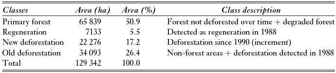
A total of 129 342 ha of Paragominas were defined as RAPP by our analysis, accounting for <7% of the municipality area. In 2010, 44% (56 369 ha) of this area was deforested (cumulative deforestation). When combining both currently deforested and regenerating areas, the total area of RAPP in the municipality that has been deforested at some time in the past rises to c. 49% (63 502 ha). Primary forest (undisturbed + degraded forests) accounts for 50.9% (65 839 ha) of the area. (Fig. 1 a, Table 1). Between 1988 and 2010, Paragominas lost 25% of all its riparian forests, a decrease of 22 200 ha, from 88 000 to 65 800 ha.
Table 1 Area (ha) and proportion (%) of each land-cover class that makes up the total area of RAPPs in Paragominas, Pará, Brazil, up to 2010.
In general, we found a very similar pattern of deforestation during 1990–2010 for both RAPPs and non-RAPPs in Paragominas, with a parallel increase in deforestation until 2004, followed by a subsequent decrease from 2004 to 2010 (Fig. 2). Comparing between different years of the study period, the proportion of deforestation in RAPPs (of total RAPP area) is very similar to the proportion of deforestation in non-RAPPs (R2 = 0.87), the regression line indicating matching deforestation patterns (χ2 < 0.01; p ≥ 0.99; df = 6; (Fig. 3 a). By contrast, when comparing levels of deforestation inside and outside RAPPs across 190 micro catchments in 2010, there was also a strong positive relationship between deforestation inside and outside RAPPs (R2 = 0.80), although deforestation was relatively greater inside RAPPs for that year (Fig. 3 b; comparison between observed and 1:1 line: χ2 = 8.69; p = 0.003; df = 4).

Figure 2 Relative biannual and cumulative deforestation in riparian permanent preservation areas (RAPPs) and non-RAPPs between 1990 and 2010 in Paragominas.

Figure 3 Relative deforestation in riparian permanent preservation areas (RAPPs) and non-RAPPs in Paragominas (a) from 1990 to 2010 and (b) across 190 micro catchments for 2010. Fitted line represents best fit from regression analysis. The 1:1 line represents the expected line if RAPPs and non-RAPPs were deforested at the same rate.
In 2010, there was a high level of spatial variability in deforestation across the municipality for the 190 micro catchments (Fig. 1 b). By plotting the difference in relative (standardized by forest area) deforestation for RAPP and non-RAPP forests for each catchment, we found that the most intensive clearance of RAPPs was concentrated in the central region of Paragominas, close to main highways. Catchments where overall deforestation was lower, the difference between deforestation inside and outside RAPPs was relatively small and generally located in the more remote areas, being concentrated in the north-east (which includes an indigenous protected area) and the south-west (which includes a large certified logging concession) (Fig. 1 b).
Regeneration of riparian forests
The relative area (%) of RAPPs and non-RAPPS that were occupied by regenerating forests in the time series was very similar (Fig. 4). Of the total RAPP that was mapped either as regeneration or deforestation in 2010 (63 680 ha), 28% (17 555 ha) was classified as deforestation every two years after 1988; 55% (34 925 ha) was classified as deforestation but under regeneration at some point between 1988 and 2010; and 17% (11 198 ha) was classified as regeneration in 2010 (Fig. 4 a). Similar relative values were found outside RAPPs: 28% (204 346 ha) has been classified as deforestation every year since 1988, 56% (401 058 ha) as deforestation following prior regeneration and 16% (119 141 ha) as regeneration in 2010 (Fig. 4 a).

Figure 4 History of (a) deforestation and regeneration detected in 2010, inside and outside riparian permanent preservation areas (RAPPs) and (b) age of regeneration detected in 2010, inside and outside RAPPs in Paragominas.
The regenerating forests detected in 2010 were of different ages. Excluding areas younger than four years old, most of the regenerating forests detected in 2010 were 5–10 years old (53% or 5900 ha), followed by forests in more advanced successional stages (17–22 years; 25% or 2800 ha) and the intermediate forests (11–16 years; 21% or 2300 ha). Values were similar for forests outside RAPPs with 51% (60 400 ha), 27% (32 500 ha) and 22% (26 100 ha) cover for each of the respective age classes (Fig. 4 b).
RAPP environmental liabilities by land tenure
The RAPP environmental liabilities for 2010 were evaluated for each major type of land tenure in the region (CAR, agrarian reform settlements, indigenous lands and unregistered private lands) under the new Forest Code (Brazilian Federal Law No. 12.651, 25 March 2012) (Fig. 1 c, Table 2). Each class of tenure presented a broadly comparable percentage of RAPP deforestation (as a percentage of number of landholding with RAPP), ranging from 80% (37 properties out of 46) for small properties (110–220 ha) to 93% (14 properties out of 15) for settlements (Table 2). In indigenous lands, small isolated areas were classified as deforested, but may actually be associated with naturally non-forest areas (such as sand banks).
Table 2 RAPP environmental liabilities detected in 2010 by land tenure (private properties registered in CAR, settlements, indigenous land and private but not registered lands), under the new Brazilian Forest Code (Brazilian Federal Law N° 12.651, 25 March 2012), in Paragominas (Brazil). 1Proportion of deforested RAPP in this category. 2Contribution of this category to the total deforested RAPP. 3Proportion of deforested RAPP to be restored in this category.

Considering all types of land tenure, we found that c. 40% (52 383 ha) of the total RAPP area was in a deforested state in 2010. Large private properties account for 68% (35 718 ha) of the total deforested area, followed by unregistered private lands with about 17% (8631 ha) and medium properties with 7% (3588 ha). Under the new Brazilian Forest code, 94% (49 110 ha) of the total RAPP deforestation in Paragominas to date must be restored. This is less than 100%, as small properties need only restore 5–15 m wide RAPPs (36 186ha), depending on the size of the property. Agrarian reform settlements were considered as needing to restore 5-m wide RAPPs (542 ha) since most smallholdings were assumed to be smaller than this (Table 2; Supplementary material, Table S4).
DISCUSSION
We found no evidence that riparian forests have been more effectively protected than non-riparian forests in Paragominas. The percentage of forest loss was, in fact, comparatively higher inside than outside RAPPs as recently as 2010, indicating a widespread lack of compliance with environmental legislation. This failure of compliance was further illustrated by a lack of evidence for higher levels of regeneration in riparian zones, where, according to the Brazilian Constitution (Article 225, §3°; http://english.tse.jus.br/arquivos/federal-constitution), property owners have been obliged since 1988 to restore areas that have been cleared illegally.
Deforestation of RAPPs in Paragominas (1988–2010)
There are similar deforestation patterns inside and outside RAPPS, with increasing deforestation until 2004 followed by a decrease from 2004 to 2010 that can be linked to government and civil society efforts to control deforestation in the Amazon generally, which started in 2004 and intensified after 2007 (Barreto & Araújo Reference Barreto and Araújo2012; Guimarães et al. Reference Guimarães, Veríssimo, Amaral and Demachki2011). For example, in 2004, the Plan of Action for the Prevention and Control of Deforestation in the Amazon (PPCDAM) was launched (MMA 2004), accompanied by an intensification of monitoring and enforcement activities by government agencies. In 2008, Paragominas began the ‘Green Municipality’ project and, in 2009, signed the Zero Deforestation Agreement (Frente Parlamentar Ambientalista 2008) with the federal government. The Green Municipalities Programme of Pará State (Whately & Campanili Reference Whately and Campanili2013) started in 2010, and Paragominas was the first municipality in Brazil to leave the deforestation Red List (Guimarães et al. Reference Guimarães, Veríssimo, Amaral and Demachki2011; Viana et al. Reference Viana, Coudel, Barlow, Ferreira, Gardner and Parry2012).
According to Brazilian Law (both the old and new version), only low impact activities (such as ecotourism) are allowed in riparian forests in consolidated areas (areas deforested before 22 July 2008). Therefore, we expected that the proportion of RAPP forest cover would be higher and more stable throughout the study period compared to areas away from RAPPs where deforestation is partly allowed. However, deforestation of riparian forests followed the same general trend as deforestation elsewhere in Paragominas. Moreover, in relative terms deforestation was actually greater inside versus outside RAPPs in 2010. This finding may be because RAPPs are commonly cleared to provide access for animals (especially cattle) to water courses. Even when riparian forests remain, they are often accessible to cattle, resulting in damage from trampling, grazing and erosion (Kauffman & Krueger Reference Kauffman and Krueger1984).
The spatial variability we observed in deforestation in different catchments in 2010 clearly demonstrates that clearance of RAPPs is related to the history of land-use change and occupation in the region. The colonization of Paragominas started with the opening of the Belém-Brasília highway (BR-010) in 1970 in the centre of the municipality, where we found the highest levels of RAPP clearance, and then spread to surrounding areas (Fig. 4). The north-east and south-west regions of the municipality are the best preserved today, with the latter being mainly occupied by a large certified forestry company, and the former being located partly in the Alto Rio Guamá indigenous reserve.
Regeneration of riparian forests
Under the new Brazilian law (Law No. 12.651, 25 March 2012), low impact activities in consolidated RAPPs are allowed. However, depending on the size of the private property, a deforested RAPP must be partly restored to at least 5 m (Supplementary material, Table S4). Thus, in areas that have been cleared, forest regeneration may be expected to be proportionally higher inside RAPPs compared to elsewhere. However, the results show that regenerating forests represent only 18% of the total area mapped inside RAPPs as deforestation or regeneration in 2010, compared to 16% in non-RAPPs. Stages of forest succession detected in 2010 were also very similar for both RAPPs and non-RAPPs, being dominated primarily by younger forests (4–10 years old).
Forest regeneration may have increased in the region in the period 2011 to present, especially following the revision of the Forest Code in 2012. However, we do not believe this is the case, because interest and enthusiasm for new regeneration projects has stalled across Pará due to the lack of state regulations necessary to implement the federal legislation (including the Environmental Regulation Programme and Environmental Reservation Quotas, abbreviated to PRA and CRA, respectively, in Portuguese), as well as delays in moving from the simple land registry (CAR) to the full property environmental licence (LAR). In addition, regenerating forests < four years old cannot be readily distinguished from agricultural fallow areas (deforestation) in the satellite record, making it impossible to assess the extent of recent regeneration.
The latest version of the Forest Code only came into law in 2012 and it is therefore likely to be too early to measure its impacts on forest restoration in the Amazon, especially using moderate resolution imagery such as Landsat. However, as the Brazilian constitution requires environmental damage to be restored, the new Forest Code remains basically the same regarding the requirements for RAPP restoration in larger properties.
RAPP environmental liabilities by land tenure
When comparing different land tenure classes, larger properties (> 825 ha) contributed the most to the total area detected as deforestation in RAPPs in Paragominas in 2010, because they cover 69% of the total area of Paragominas. Conversely, small (≤ 55–220 ha) and medium (220–825 ha) properties, and settlements were the land tenure classes with the highest proportion of RAPP (relative to their total areas) in a deforested state in 2010 (mean 56.8%; small properties 61.5% and medium properties 47.2%). Thus, the planning and implementation of restoration activities need to focus on both large and small properties (Table 2).
The higher relative deforestation of RAPPs in smallholdings may be because subsistence farmers face much greater economic challenges in achieving legal compliance. Previous work has shown that many smallholders are unfamiliar with legal prescriptions of what comprises an APP, and where and how to restore areas that have been cleared (Sá Reference Sá2008; Sá et al. Reference Sá, Almeida, Rivero, Nepstad and Stickler2008), as well as the kind of financial support potentially available to them (Cardoso Reference Cardoso2011). More generally, it is possible that RAPP restoration is not afforded high priority (compared to the restoration of legal protected areas) by many land owners, as the use of these areas for economic purposes is limited (for example, timber extraction is not allowed). Nevertheless, smallholder farmers in Paragominas encompass a diverse array of landowners, from traditional ribeirinhos to more recent colonist farmers and inhabitants of agrarian reform settlements; further research is needed to understand possible differences in compliance with environmental legislation among these groups.
Challenges and barriers to protecting and restoring riparian forests in the Brazilian Amazon
In order to mobilize and guide large-scale public policies for the restoration of riparian forests in the Brazilian Amazon, a number of challenges need to first be addressed. First, more accurate cartographic products are required to determine the extent of APPs (including RAPPs). The accuracy of APP maps in the Amazon is limited by the quality (or lack) of mapping data in the region, including high resolution and recent digital elevation models to inform improved hydrological models and quantification of the width of water courses (Silva et al. Reference Silva, Felix, Zacari, Milhomens, Menke, Oliveira and Souza2013) and, critically, field validation data to establish whether water courses predicted by digital elevation models actually exist on the ground.
The RAPP mapping presented in this study is based on a 90-m resolution digital elevation model (DEM) of the space shuttle topographic mission (SRTM) from 2000 and refined using 5-m RapidEye images (which satisfy the mapping scale required by law). No ground-truthing was performed, and deforestation in RAPPs during the full time period was assessed using a 30-m spatial resolution (Landsat). Our mapping of RAPPs, and hence assessment of deforestation patterns, may be subject to both negative and positive biases. For example, our analysis may have overestimated the current distribution of water courses, as small streams predicted by this approach may only be dry topographic depressions on the ground. Small streams are also the most threatened by land-use change and forest loss (Iwata et al. Reference Iwata, Nakano and Inoue2003; Biggs et al. Reference Biggs, Dunne and Martinelli2004), and it is hard to evaluate whether their absence from agricultural landscapes today means that they did not exist prior to recent deforestation (instead of being a natural phenomenon). Conversely, we may also have underestimated RAPPs, as the DEM resolution used in this study may have been insufficient to map smaller or transient streams that exist in the field but were not projected by the water courses mapping approach.
Addressing these problems is beyond the scope of this study, requiring higher resolution and more recent DEMs, historical information on stream extent and width, or the development of more realistic water course mapping approaches in undisturbed regions of the Amazon that can be extrapolated to human-modified areas such as Paragominas.
A second challenge, which compounds the problems of defining the extent and distribution of RAPPs, is a pervasive lack of clarity about what is legally considered to be a RAPP under Brazilian law. This, in turn, undermines confidence in defining the conservation and restoration responsibilities of a landowner in order to become compliant with the law. For example, it is unclear whether RAPPs should also be enforced in areas with irregular flows that may only contain water during severe storms or for a limited time in the peak of the wet season. Often these specific decisions are left to the subjective (and therefore variable and inconsistent) judgment of local environment agency enforcement officers.
A third major challenge is to improve the development of, and access to, reliable information on property boundaries and registration in the CAR system. The Brazilian Secretary of State for the Environment (SEMA) estimates that among 100 000 properties registered in CAR in the state of Pará, only 4000 have been validated (the boundaries declared by property owners have been checked on the ground) (M. Ausier, personal communication 2013), indicating a serious lack of technical capacity in the state government. Moreover, even in Paragominas, 15% of the municipality is still composed of unregistered private lands (private properties that have not registered for CAR). This figure is much higher in other municipalities in the Amazon, and the spatial coverage of CAR remains very low in some places, such as Cametá (3%) and Barcarena (7%) (Green Municipalities Programme & Government of the State of Pará 2013).
A fourth challenge to implementing the restoration actions necessary to achieve environmental compliance is that land owners often do not have access to sufficient financial resources or technical support to implement the work. Where credit lines are available to support restoration activities (for example through PRONAF [Programa Nacional de Fortalecimento da Agricultura Familiar] or Fundo Amazônia), individuals are often unaware that they exist, or how to access them (Cardoso Reference Cardoso2011). Other economic incentives, such as payment for ecosystem services (PES), are poorly established, partly as a consequence of the lack of federal governmental regulation of such incentives (Santos et al. Reference Santos, Brito, Maschieto, Osório and Monzoni2012). In situations where individuals are able to access credit, information on costs and technical assistance is often poor or non-existent, and the logistical support necessary to actually implement restoration is often lacking (such as provision of seeds, access to nurseries and technical support in planting efforts). Even in flagship areas such as Paragominas, there are only a few relatively small-scale restoration initiatives. As such, economic incentives and education programmes should be given greater priority over further command and control actions, especially if compliance is to be improved amongst more vulnerable smallholders (Brancalion et al. Reference Brancalion, Viani, Strassburg and Rodrigues2012).
CONCLUSIONS
The legal protection given to riparian forests by Brazilian environmental law has not been sufficient to prevent them from being deforested in Paragominas, a flagship municipality for land-use sustainability in the Brazilian Amazon. By contrast, we found that deforestation inside riparian APPs was greater than deforestation outside RAPPs, even as recently as 2010. We also found that regeneration of deforested RAPP areas has fallen far short of what is needed for private properties to comply with legal requirements (whether prior to or after the revision of the federal Forest Code). Priority for restoration action must focus on larger properties because they account for most of the deforestation within RAPPs in Paragominas and across much of the Amazon. However, smaller properties, which include some of the poorest and most vulnerable people in the region, exhibit the highest relative rates of deforestation in RAPPs (deforestation as a proportion of total RAPP area), also require much greater attention, including the provision economic incentives and technical support on where and how to restore.
The development of more accurate maps of RAPPs and RAPP deforestation (combined with ground truthing of remotely sensed data) is an important first step in guiding efficient large-scale forest restoration action. Paragominas has seen some success in initial restoration projects and a major challenge remains in strengthening and upscaling these examples to other regions that have weaker levels of environmental governance.
Some of the issues we have discussed no longer present barriers to restoration in Paragominas (such as insufficient registration of properties in CAR) given the significant efforts made by civil society and government to remove the municipality from the Red List (Viana et al. Reference Viana, Coudel, Barlow, Ferreira, Gardner and Parry2012). Initiatives like the Green Municipalities Programme (PMV in Portuguese), inspired by the experience of Paragominas, with their alliance of public, private and civil society partners, are improving compliance of private landowners, promoting forest restoration, reducing deforestation, and helping to improve clarity over land tenure. Although the birth of PMV has been heralded as conservation success story that marks a positive shift towards increased environmental conservation and awareness (Guimares et al. Reference Guimarães, Veríssimo, Amaral and Demachki2011; Viana et al. Reference Viana, Coudel, Barlow, Ferreira, Gardner and Parry2012), it is too soon to evaluate its success in achieving widespread compliance with Brazil´s environmental legislation.
ACKNOWLEDGEMENTS
We thank the Porticus Fundation and World Resources Institute for supporting this research. Toby Gardner thanks the Swedish Research Council Formas (Grant 2013-1571). We also thank Imazon and Sustainable Amazon Network's team, especially Rodney Salomão, Marcio Sales, Sérgio Silva, Luis Oliveira Jr, Dário Cardoso Jr, Elis Araújo, Gabriela Góes, Ricardo Solar and Erika Berenguer for support in the analysis. This is publication 28 of the Sustainable Amazon Network publication series (www.redeamazoniasustentavel.org).
Supplementary material
To view supplementary material for this article, please visit http://dx.doi.org/10.1017/S0376892914000356.


