Introduction
The typical medieval Scottish town was set within a framework that, with or without formal defences, consisted principally of land or burgage plot boundaries and of street or other public access lines. Here, as elsewhere, such frameworks are known to have contributed to overall patterns of urban development and planning over the centuries, but the possibility that such frameworks might also have had a bearing on the location, design and character of individual buildings or groups of buildings is an issue which, at least in Scotland, has tended to remain under-explored. In an attempt to close what appears to be a cross-disciplinary gap, this article thus examines certain key practices and features of layout which may have directly or indirectly influenced some of the forms of urban domestic architecture in late medieval and early modern Scotland.
Successive generations of buildings are known to have been configured within or across land plots, so key practices for examination here have included the setting out and maintenance (or otherwise) of plot boundaries. An appreciation of the physical context has also demanded further scrutiny of bodies of relatively dispersed evidence for the ways in which buildings impinged upon their neighbours or fronted upon main thoroughfares and subsidiary access passages.Footnote 1 This article thus provides an opportunity to bring together and to re-examine what is known or knowable about site constraints in relation to both the forelands and backlands of Scottish urban properties, and in particular about the nature and construction of building frontages and so-called ‘encroachments’ such as booths, stairs, galleries and arcades.
As well as taking account of documentary, archaeological and architectural evidence relating to changes in building frontages and frontage lines, the approach adopted here also makes use of a quantitative methodology developed in recent years to characterize plot patterns in eight towns in Scotland and the north of England. The results of these studies are available in three papers concerning respectively: Edinburgh, Canongate, St Andrews and Perth; Edinburgh and Elgin; and Alnwick, Berwick-upon-Tweed and Cockermouth.Footnote 2
Cartography made an important contribution to these papers. Despite the considerable physical pressures on built urban environments in modern times, many Scottish burghs of medieval origin still exhibit much of their basic early layouts; even more of their detail, including features lost in modern times, may be studied in the large-scale Ordnance Survey Town Plans which were first produced in the 1850s and which, for Scottish towns, are accessible in digital format online (Figure 1).Footnote 3 The maps were originally printed at scales of 1:500, 1:528 or 1:1,056 and have been digitized so that one pixel roughly represents six inches on the ground. Cross-checks against surviving features have shown that the maps may be used to determine dimensions to within about one foot or ±0.3 metres, a range of accuracy that is perfectly acceptable for exercises of this kind.

Figure 1: Lawnmarket and upper High Street, Edinburgh; a specimen map from the Ordnance Survey Town Plans, Edinburgh series, sheet 35, first edition, 1849–53. Reproduced by permission of the Trustees of the National Library of Scotland.
Establishment and maintenance of plot boundaries
The earliest of the Scottish burghs, including Edinburgh, were formally founded and chartered just before or in the decades after 1124,Footnote 4 generations and in some cases centuries later than their English counterparts, from which they borrowed and adapted many established customs and practices.Footnote 5 The ‘ancient’ laws of the burghs of Scotland were subsequently developed to provide a clear legal framework for their orderly functioning. The first record of the laws dates from c.1270 at the earliest, but they are thought to be based on the mid-twelfth-century customs of Newcastle upon Tyne. One such law held that
the provost in the presence of and in consultation with the community of the burgh shall choose liners (lineatores), at least four wise and discrete men, such that no complaint is made to the King's Chamberlain for dereliction of lining . . . The said liners shall ensure that they faithfully line in length and breadth, both foreland and backland, according to the original lawful divisions within the burgh.Footnote 6
One later document describes the duties of the liners ‘who define the boundaries of the tofts (plots) and ensure there is no encroachment’ while another records the ‘strobing’ (staking) of a plot 3 rods in length and 24 feet (7.32 metres) in width. On and after burgh foundation, the Scottish burgess liners remained competent to undertake the continuing process of setting out the plots, but there is evidence that both in Scotland and in England experienced persons were brought in at an early stage to administer the start-up.Footnote 7
The Ordnance Survey Town Plans indicate that plots are of varying widths in each of the eight Scottish and northern English towns referred to above, a phenomenon first reported by M.R.G. Conzen over 50 years ago.Footnote 8 These plots are now better understood, forming consistent patterns of quarter variations of a unit width, the unit width varying from location to location in each town. In Cockermouth, plot width appears to have been a critical determinant in the assessment of annual rents due to the burgh superior, being set there in 1270 at 4d per ‘complete plot’, which was clearly the same as a unit plot.Footnote 9
Plots of three-quarters of a unit, one and a quarter, and up to two and a half units are encountered in all eight towns that formed the subject of study. Comparison of the cartographic and early documentary evidence suggests that plot boundaries as initially set out in Scotland remained unmodified in later times, although many of the broader plots were on occasion carefully divided into two narrower plots which also conformed to the quarter plot scheme. The effectiveness both of the initial layout procedures and of the tight control exercised over the plots and their boundaries down the centuries is impressive. In a sample of 49 Edinburgh plots subjected to analysis, approximately two-thirds were found to be within ±0.5 metres of the precise quarter width.
The burghs expanded at different rates as new plots and facilities were required. Edinburgh, for example, received its charter in about 1124 and a toft below the castle at the upper (west) end of the High Street is recorded in a document dated between 1143 and 1147.Footnote 10 Here, plot layout proceeded eastwards to the site of the original church, and then extended in what appears to have been a further phase indicated by a change of unit width. By 1400, plots had been set out over the full length of the main street with single dwellings located on plot forelands, the area closest to the street. By 1490, there were also dwellings on about one third of the backlands. A century later, the plots were full, and new land was being appropriated for further expansion.Footnote 11
The liners’ responsibility for maintaining plot boundaries ‘in length and breadth’ included maintenance of the integrity of property boundaries at the street line. The penalty for intrusion into the king's street was re-emphasized in the findings of a court case of 14 November 1497, which involved purpresture, that is, the illegal occupation of anything pertaining to the king, in this case, the king's street. The findings stated that ‘If any person builds houses or tenements upon the common street within any of the king's burghs the same aught and should pertain to the king's highness . . . and may be given and disponed by him to anyone.’Footnote 12 Control of the street line was firmly enforced, but special royal assent provided some flexibility. An early example of such assent in favour of a corporate body was David II's charter of 3 December 1365, granting to the burgesses of Edinburgh a piece of land next to the old tolbooth in order to build a new tolbooth.Footnote 13 Assents in favour of individual burgesses in Perth, Edinburgh and Linlithgow are referred to below.
Building frontages and street lines
Archaeological evidence has shown that, initially, in the twelfth and thirteenth centuries, many foreland buildings were set back, typically by some four to six metres, from modern-day street lines. Examples have been found in Aberdeen, Arbroath, Dumbarton, Inverness, Montrose and Perth, often with the front areas surfaced with hard standing, occupied by light structures, such as booths, and displaying evidence of manufacturing activities.Footnote 14
Especially in view of the care with which street encroachments were controlled, it seems likely that owners had not casually occupied the flanks of streets that had originally been significantly broader, but, rather, by their own choice, had deliberately set back their main foreland buildings from the street line in order to create working or commercial spaces on their own plot frontages.Footnote 15 An early example of such a booth created on an owner's plot is found in Perth, where between 1153 and 1156 one Baldwin was granted a small plot of land, with the right to sell the plot and the dwelling if he so wished. A decade later, between 1165 and 1169, the property then also contained a booth.Footnote 16
There may indeed be a correlation between the incidence of foreland dwellings set back from street lines with areas where market activities were concentrated. The converse certainly appears to hold good. At the west end of Main Street, Cockermouth, Cumbria, for example, well away from the main market area, the excavated frontages of two timber-framed foreland buildings of thirteenth- or fourteenth-century date were found to be located within a fraction of a metre of the present street line, and a similar pattern, involving three fourteenth-century buildings, has been observed in Castle Street, Inverness.Footnote 17
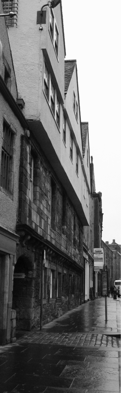
Owners of ‘set-back’ properties would, in theory, always have been in a position to occupy the frontage space more permanently and to make alternative arrangements for their manufacturing and sales activities. Indeed, a high proportion in the larger towns eventually did so. At Gladstone's Land, Lawnmarket, Edinburgh, for example, the ground-floor frontage was brought forward 23 feet (7 metres) to its present position on the early street line following Thomas Gladstone's purchase of the building in 1617.Footnote 18 Elsewhere, however, as in Linlithgow, there are clear indications that frontages, generally of no more than three storeys, continued to be brought forward until comparatively recently, and a small number still stand set back from the street line (Figure 2).Footnote 19
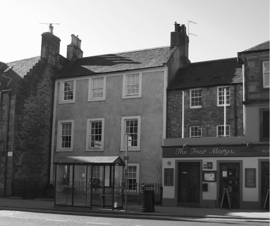
Figure 2: 63 High Street, Linlithgow, West Lothian; view of set-back street frontage from north-east, 2014.
On making moves to a street line, owners were subjected to close control, but in royal burghs it was possible to obtain royal grants to make small-scale intrusions into, under and even above the king's street. For example, in Perth in 1363 John de Petscottie was allowed to build a four-feet wide forestair on the street outside his dwelling in order to provide direct access to the upper floor (‘una cum uno gradu lapideo de latitudine quatuor pedum construendo in via nostra communi in fronte dicti tenementi sui’).Footnote 20 In the course of time, such applications became more frequent, some applicants seeking permission to install vaulted cellars, occasionally with an access stair, under the street in front of the building.Footnote 21 Even turnpike (spiral or newel) stairs serving upper floors were allowed. By 1483, Robert Bell had already been granted royal permission to construct a stone stairway to his property in Blackfriars Wynd, Edinburgh, for ‘entry to the said land just as [access] now extends along the side of the house’. Due to the sloping nature of the site alongside the wynd (a narrow minor public street or lane), the entry to the main floor at the forefront was up a few steps, and the document makes clear that the building had a gallery of unspecified character which extended across the entire frontage (‘cum le galry per totam spacium dicte principalis terre in longitudine extendente’) and which would be reached by the new foreland turnpike.Footnote 22
Storeyed foreland and backland buildings
Documentary evidence from Perth that is relatively early by Scottish standards indicates the presence of solars, private rooms on upper floors of dwellings. One is recorded as having been used as a refuge during serious flooding in 1210, while in 1363 a Perth burgess was granted permission to erect a forestair to his dwelling to provide access to ‘solaria’, that is more than one solar, on an upper floor or floors.Footnote 23 Further direct or indirect evidence of multi-storeyed and probably timber-constructed dwellings is scant, patchy and inconclusive until the late fifteenth century when surviving notarial protocol records of urban property ownership begin to become available, some of which provide helpful descriptions of the properties involved.
For example, two related early sixteenth-century protocols concern a foreland property in Edinburgh, parts of which Archibald Preston and his spouse sold to Andrew Uddart in 1504: they ‘resigned their dwellings, under and above, containing a hall, chamber and kitchen now occupied by Andrew Uddart, and another hall and chamber, with two cellars and a stable . . . and the rest of the said tenement’.Footnote 24 Shortly afterwards, in 1509, the same pair ‘resigned their booths in the fore tenement occupied by John Falcone, Andrew Uddart, John Schaw and Simon Young, and the hall, kitchen and chamber, with the stair, inhabited by themselves . . . on the north side of the street’.Footnote 25 The word-picture created by this pair of documents is of a large building on at least three levels. On each of the top two floors there were separate dwellings, each consisting of a hall, a kitchen and a chamber. At ground or basement level, there were four booths, two cellars and a stable.
Roughly contemporary with these is a record of a transfer of ownership within the Hopper family in 1508, a transaction which related to both foreland and backland properties in Edinburgh: ‘the foreland containing a hall, chamber, kitchen and lofts, with three cellars, . . . and his land immediately behind . . . containing a hall, chamber, kitchen with lofts and the stair towards the north, called the gallery, with a middle hall and three cellars’.Footnote 26 Here, the foreland building appears to have been on two floors above a basement, while the backland building also had two floors above a cellared basement, together with lofts above, reached from an external stair. The fact that building was referred to as ‘the gallery’ strongly suggests the presence of a galleried upper floor.
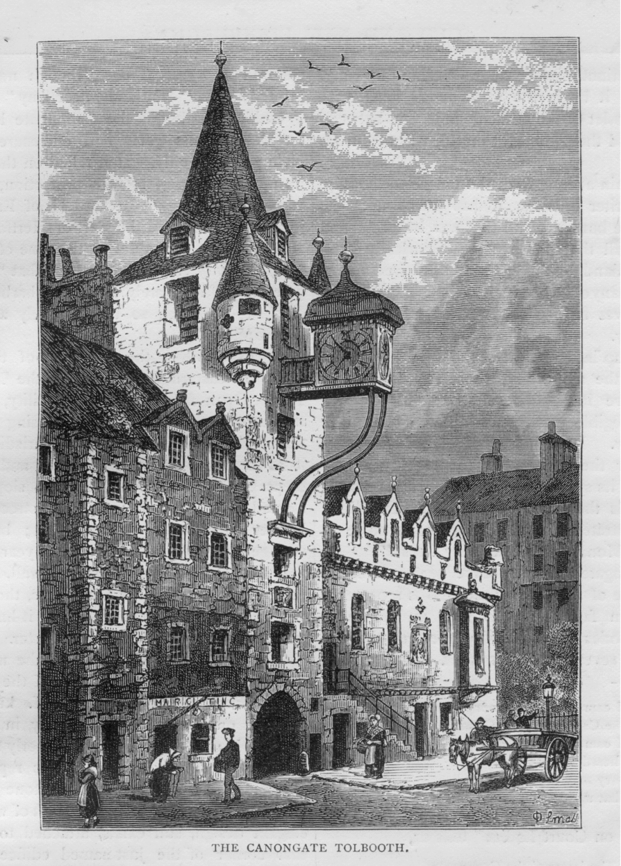
Being on upper floors well above ground, such projecting timber galleries were permitted but their construction appears to have been subject to regulation. In Edinburgh, an Act of Common Council, evidently designed to encourage the use of timber from the Burgh Muir that had been granted to the burgh in 1508, allowed owners to support the upper storeys using timber pillars located 7 feet (2.13 metres) into the street, maintaining through pedestrian access at street level.Footnote 27 Canongate Tolbooth (Figure 3) appears to provide a subsequent masonry-built example of the application of this act. In 1477, the tolbooth occupied the forelands of two tenements on the north side of the Canongate, but by 1571 expenses were being allocated to modify the building and to extend it westward over the neighbouring plot, replacing a dwelling house there.Footnote 28 The frontage of the new section was advanced forward relative to the earlier one by a distance of 7 feet 3 inches (2.2 metres), and public access was maintained by the creation of a pend (a covered, tunnel-like passage, usually arched), which was almost as broad as the new building frontage, leading through into the newly created Tolbooth Wynd.Footnote 29 Evidence for similar arrangements in other Scottish burghs currently remains unknown to the authors.
Figure 3: Canongate Tolbooth; engraving from James Grant, Cassell's Old and New Edinburgh (London, 3 vol. edn, n.d. [c. 1880]), vol. II, 1.
Frontages and galleries of timber and stone
According to the most reliable estimates, at the Reformation in 1560 the population of central Edinburgh within its walls was about 12,500, while ‘greater’ Edinburgh, including Canongate, Leith and adjacent suburban baronies, was probably in the range of 15,000–18,000. By 1635, the central Edinburgh figure had doubled to around 25,000, and by the 1690s best demographic calculations indicate a range of 27,000–30,000 within an overall conurbation of some 40,000–47,000.Footnote 30 Given the pressures of such population growth on limited land space, it is not unreasonable to assume that plot width constraints and relatively fixed property boundaries would have contributed significantly to the general tendency towards building tall, long recognized as a distinctive characteristic of Scottish urban architecture, especially, but by no means only, in Edinburgh. Such factors are also likely to have had an indirect bearing on the creation of the internal subdivisions that accompanied multiple occupation and ownership, one of the most obvious outward visible manifestations of such flatting being the staircase, often in the form of an external forestair rising, with royal or council consent, from the street or contained within an extruded turret at the front, side or rear.Footnote 31
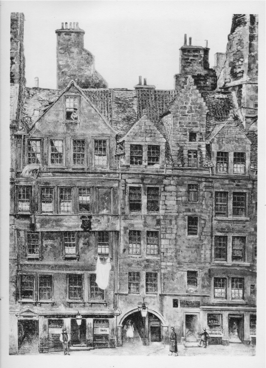
Multi-storeyed dwellings reached ever-increasing heights throughout the sixteenth and seventeenth centuries, the majority of them remaining either timber-framed or timber-fronted, often incorporating masonry ground-floor walls supporting cantilevered balconies above.Footnote 32 Such timber-fronted buildings might otherwise be almost completely encased in a masonry structural shell, while only rarely among recorded standing examples were both the front and rear walls completely or substantially of timber construction (Figure 4).Footnote 33 Recent dendrochronological evidence suggests that, on occasion, where extra floors and replacement roofs were built onto such complete timber structural assemblages, they were added on a platform-by-platform, ad hoc basis, presumably increasing the loads on the lowest beams and posts (Figure 5).Footnote 34
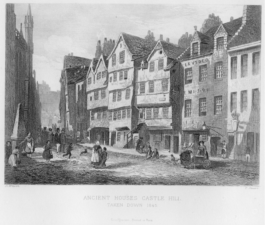
Figure 4: Old Houses, Castlehill, Edinburgh; engraving from Daniel Wilson, Memorials of Edinburgh in the Olden Time (Edinburgh and London, 2nd edn in 2 vols., 1891), vol. I, frontispiece.
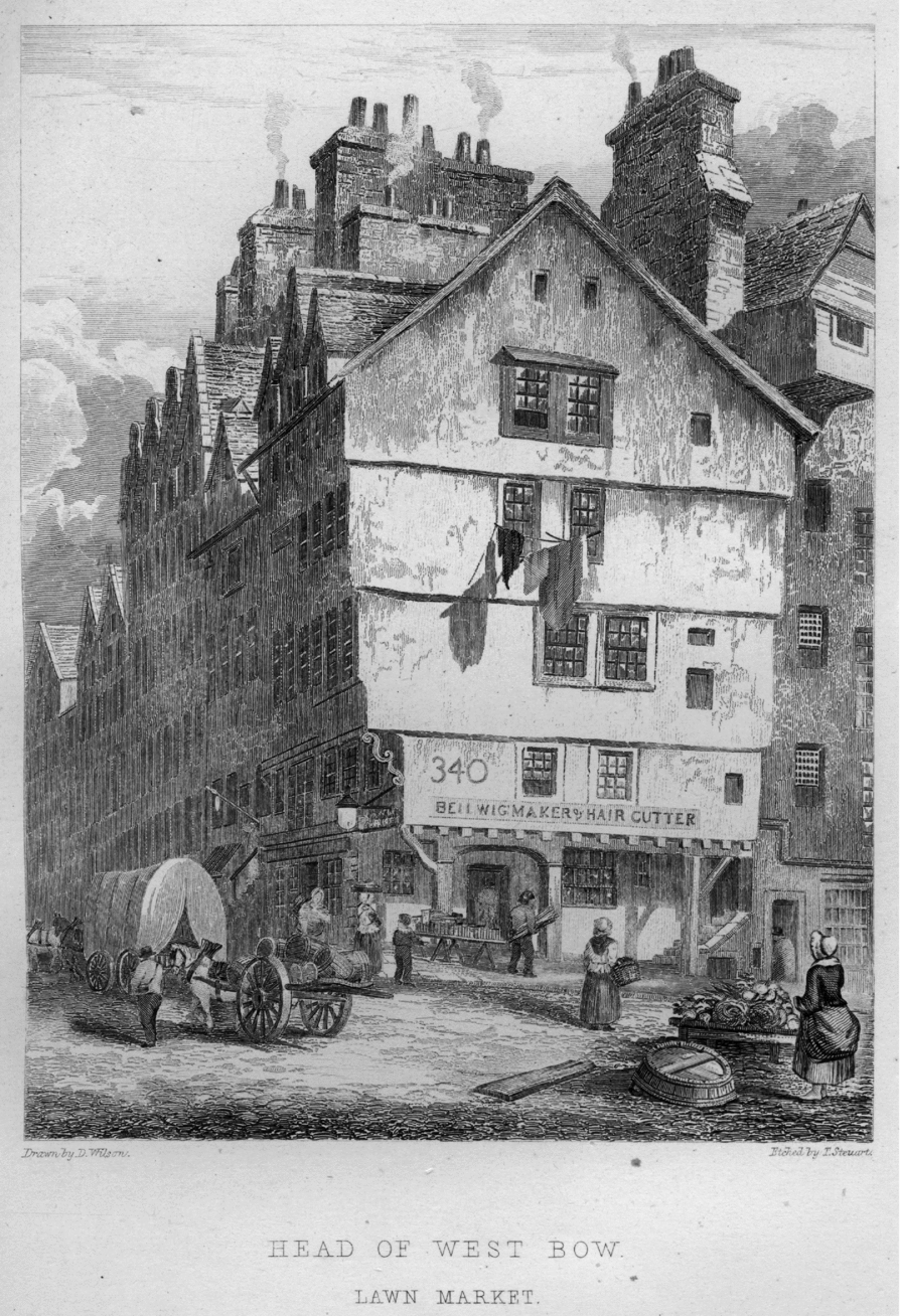
Figure 5: Bowhead, West Bow and Lawnmarket, Edinburgh; engraving from Daniel Wilson, Memorials of Edinburgh in the Olden Time (Edinburgh and London, 2nd edn in 2 vols., 1891), vol. II, opposite 156.
In Scotland as elsewhere, no evidence has been found to show that jettying of upper floors on street frontages was specifically regulated. By the fifteenth century, a projection of between 1 foot 9 inches and 2 feet (52–60 centimetres) at each level was the norm among English timber-framed town houses.Footnote 35 Such slight surviving or recorded evidence suggests that cantilevered projections were equally modest in Scotland; the corbelled and double jettied frontage of Huntly House, Canongate, for example, appears to be only slightly beyond the English standard with a total cumulative overhang beyond the inserted front wall of about 2 feet 6 inches (76 centimetres) (Figures 6A and 6B).Footnote 36
Figure 6A: Huntly House, 142–6 Canongate; engraving from Bruce J. Home, Old Houses in Edinburgh (Edinburgh and London, folio edition in 17 parts, 1907), part 5.
Figure 6B: Huntly House, 142–6 Canongate; oblique view of jettied frontage from east, 2014.
By the late sixteenth and early seventeenth centuries, stone-built colonnades of fashionable Italian and French Renaissance styles, which in turn harked back to the arcaded galleries of medieval market squares of continental Europe, were beginning to find their way into Scottish burghs, one of the first Scottish arcades of this type having been introduced into Crichton Castle by the 5th earl of Bothwell after 1581.Footnote 37 The style became widespread across urban Scotland with known examples occurring in Edinburgh, Leith, Linlithgow, Dunfermline, St Andrews, Glasgow, Dumbarton and Elgin, but to what extent such stone arcades were direct replacements of timber-pillared and trabeated, that is, post-and-lintel, galleries is difficult to say (Figure 7).Footnote 38 Certainly, by continuing to limit the ground-floor frontage to the street line common access was still being maintained behind the colonnades as part of the public street. Archaeological excavations within the Tron Kirk in Edinburgh, for example, have revealed a section of a seventeenth-century road surface bordered by the base of an arcade column, perfectly aligned with the present street frontage.Footnote 39
Figure 7: 101 High Street, Elgin, Moray; engraving of 1680 building with arcaded stone frontage (demolished in the late nineteenth century) from Robert W. Billings, The Baronial and Ecclesiastical Antiquities of Scotland (1845–52 edn republished in 4 vols., Edinburgh, 1901), vol. II.
Such developments reflect growing contemporary preferences for urban architectural harmony and uniformity, then being taken to considerable lengths in the Paris of Henri IV (1553–1610) and long presaged by fourteenth-century Florentine new towns such as San Giovanni.Footnote 40 Meanwhile, on the other side of the stylistic coin, timber galleries were beginning to go out of favour. As early as 1598 Fynes Moryson, visiting Edinburgh from England, noted that ‘the houses are built of unpolished stone . . . which . . . in the broad street would make a faire show but that the outsides of them are faced with wooden galleries built upon the second storey of the houses . . .’. Shortly afterwards, in 1636, Sir William Brereton, also from England, expressed similar sentiments: ‘if the houses which are very high and substantially built of stone (some five, some six storeys high) were not lined to the outside and faced with boards, it were the most stately and graceful street I ever saw in my life’.Footnote 41
In Scotland as elsewhere, however, the greatest impetus to convert to all- or even part-stone construction came from the fire hazard that closely juxtaposed timber buildings presented, with serious fires in, for example, Dunfermline in 1624 (and 1809), Edinburgh in 1674 (and 1824) and Glasgow in 1632 and 1677.Footnote 42 Responding to the 1674 fire, Edinburgh Town Council ruled that that all ruinous or burnt tenements should be rebuilt in stone, and owners of other timber-fronted buildings were offered a period of 17 years free of taxation if they rebuilt them in stone. Because of the flammability of thatched roofs, all replacements were to be slated or tiled, subject to a fine of 500 merks and demolition, and in Glasgow, an ordinance of 1652 concerning the rebuilding of fire-damaged properties in the Saltmarket further required that ‘all houssis on both sydes of the gait be buildit conform to ane straicht lyne and none to come farder out then [than] another’.Footnote 43
Other burghs took similar measures, but matters improved only slowly. As late as 1784, for example, it was reported that ‘at this day there are people alive in Edinburgh who remember a continued range of wooden piazzas from the Weigh House [at the junction of the West Bow and Castle Hill] through the whole of the Lawnmarket and along the greatest part of the High Street’ and from an actual survey of that date ‘it was found no fewer than 44 were still in existence between the Weigh House and the head of Advocate's Close [opposite St Giles’ Church]’, a distance of about one third of the overall length of Edinburgh High Street.Footnote 44
Arcade infilling and public access
During the seventeenth century, the Dean of Guild Court in Edinburgh had been granting permission, evidently without royal authority, for the erection of forestairs and cellars which extruded beyond the street line, a position which was legally regularized in 1688 by a royal charter transferring control of the public streets to the council.Footnote 45 By the eighteenth century the Dean of Guild Court was using such powers to permit owners of foreland buildings to replace or infill colonnades with walls, thus giving them additional ground-floor private space at the expense of public access, a clear contravention of the early sixteenth-century Act of Common Council that was evidently still in force.Footnote 46
It was not until 1783, however, that a major and successful legal challenge to such practices was mounted in Edinburgh.Footnote 47 In that year, a number of prominent citizens, including the wealthy banker Sir William Forbes, appealed to the Court of Session against a Dean of Guild Court decision in favour of one John Ronaldson. Ronaldson owned a shop behind a colonnade on the south side of the High Street to the west of Gray's Close (a close being an alleyway to private property that was usually gated or ‘closed’). He used the space within the arcade on what he described as ‘an occasional basis’ to display his merchandise, and he had a stair there which gave access to a storage basement. The Dean of Guild Court agreed to and authorized his request to bring his shop front forward to enclose this area, but Forbes and the others objected on the grounds that this enclosure amounted to an intrusion into public space. A second such appeal took place in the following year.
Despite the Court of Session's finding in favour of the objectors, the process of infill continued. Similar changes took place in Elgin, and in Glasgow the council took matters even further by selling off the extra frontage space at £5 per yard.Footnote 48 In Stirling, the record of a Court of Session case of a dispute between next-door neighbours in 1750 indicated that both dwellings had already been brought forward at ground-floor level, one by 7 feet 6 inches (2.29 metres), the other by 8 feet 5 inches (2.57 metres), while in Dunfermline, a council meeting on 15 July 1741, declared that ‘there can no instance be given of any heretor [heritor] being restricted from building out as far as their stone pillars’.Footnote 49
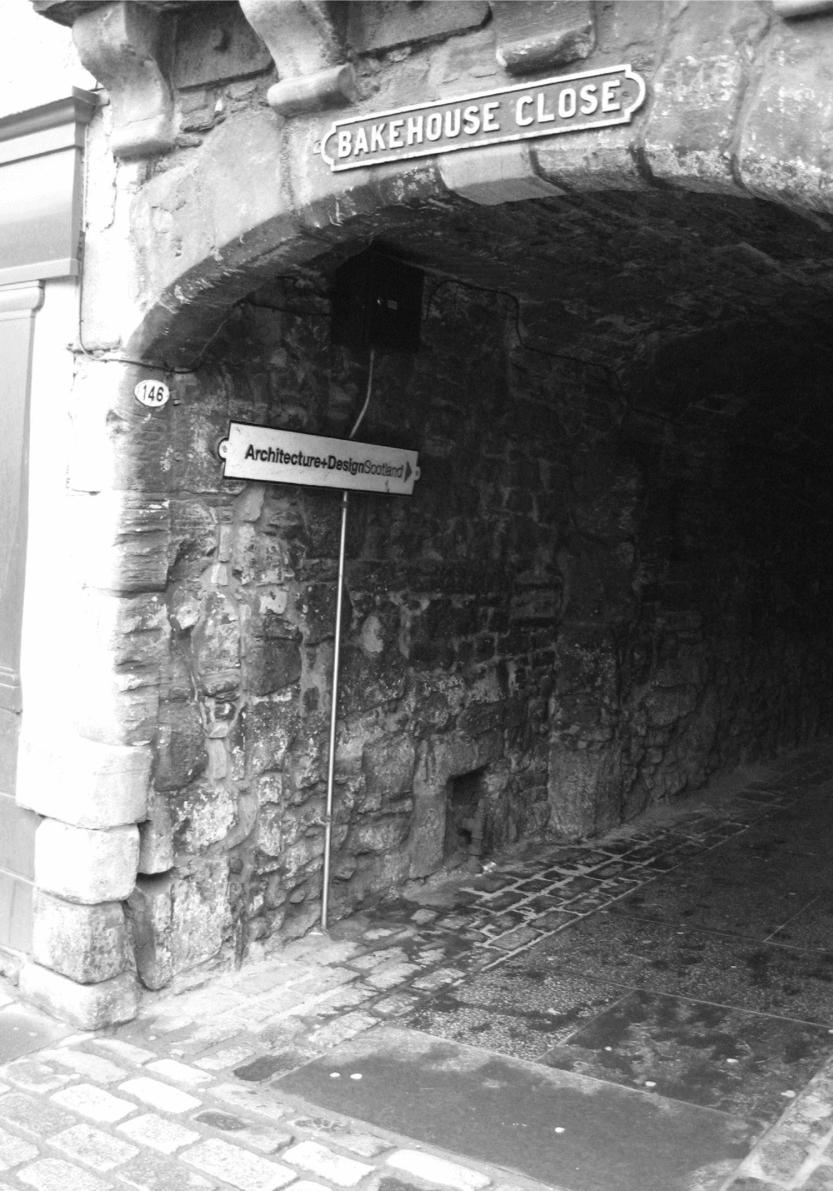
In Edinburgh, physical evidence of extended ground-floor frontages still survives here and there, especially in the access pends which were brought forward to new street lines. Set well back from modern street frontages, the walls of such pends or closes still retain vestigial jambs and occasionally the iron crooks of crook-and-band hinges on which gates were once hung, possibly demarcating the street line and pend entry in earlier times (Figure 8).
Figure 8: Bakehouse Close, Canongate, Edinburgh; view of jamb and crook hinge of former gate within pend, 2014.
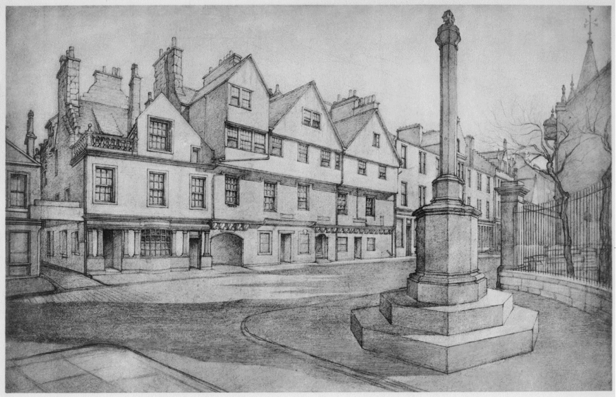
Within the buildings themselves, other related evidence may be encountered, as appears to be the case with the two-part structure at 302–4 Lawnmarket, Edinburgh (Figure 9).Footnote 50 Beneath the paired buildings there are vaulted cellars which terminate at an earlier frontage line, but have subsequently been extended beneath the present pavement. Above a pend into Buchanan Court and a later street-level shop-front, the eastern building (302) retains evidence of timber-built and jettied upper levels which have long since been modified to form a frontage in a single plane. The masonry-fronted western building (304) is made up of three distinct sections: an eastern section, which has a recessed masonry frontage, contains a single surviving arch of a colonnade which serves as a pend to Brodie's Close and with steps down into the cellar beneath; a central section, behind which is a turnpike stair to the upper floors that had been brought forward from an earlier frontage line with royal consent; and a western section whose uniform masonry frontage bears no evidence of a colonnade.
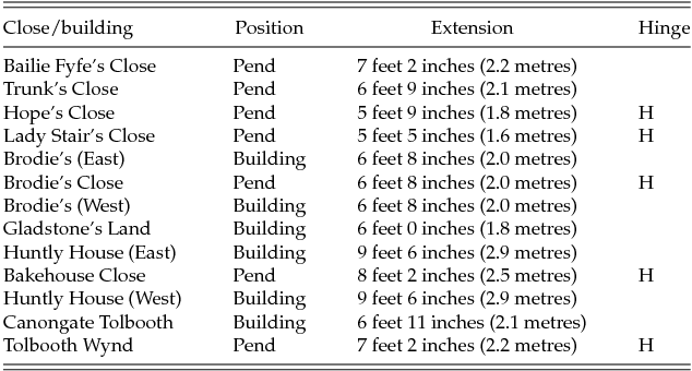
No direct historical record of the application of the Edinburgh ‘seven foot’ Act has been found, but physical examination of 13 sites in the burghs of Edinburgh and Canongate has shown a remarkably close approximation to it in the form of frontage extensions varying between 5 feet 5 inches (1.6 metres) and 9 feet 6 inches (2.9 metres), at an average of 7 feet 2 inches (2.2 metres). The spread in these numbers may result at least in part from adjustments made to provide a uniform final frontage line. Table 1 summarizes the evidence of frontage extensions on these 13 Edinburgh sites.
The cumulative effects of these foreland changes have been to project street lines inwards on both sides. In Edinburgh, a reduction in width at street level from about 23 to 19 metres would not have created a great visual impact, especially as the jettied upper floors would have become more closely aligned with the new street line, but in the narrower, more canyon-like Canongate and elsewhere a reduction from about 15 to 11 metres would have been noticeable.
Table 1 Measurable frontage extensions in Edinburgh and Canongate; surveyed measurements in the third column are given in feet/inches (metres)
Figure 9: Brodie's Close, 302–4 Lawnmarket, Edinburgh; engraving from Bruce J. Home, Old Houses in Edinburgh (Edinburgh and London, folio edition in 17 parts, 1907), part 12.
Lateral backland buildings
The relative stability of plots, and especially of plot widths, placed strict limits on the breadths of the frontages of foreland buildings, given that there had also to be lateral space for an access path or ‘close’. Enclosing the path within a pend allowed the upper floors to span the full width of a plot, but for builders of greater ambition the forelands proved too physically constricted; the backlands, on the other hand, offered scope for aligning much larger dwellings linearly along the long axes of the plots and for their main frontages to face the closes, not the streets.
A prime example is the still-surviving and substantial Bertram-Cor tower-and-hall residence, built towards the end of the fifteenth century on the backland of what became Advocate's Close, High Street, Edinburgh. Facing the close, it has a lateral frontage of 17 metres, which is more than double that which would have been available facing the street. Further down Edinburgh High Street, a large dwelling of the Lockhart family is similarly transversely aligned in the backlands of Trunk's Close. The Bertrams, the Cors and the Lockharts were all wealthy burgess families who, constrained by plot widths, appeared willing to forgo the trading advantages of a foreland property in order to build on a scale and to designs which reflected their means and their self-esteem.Footnote 51
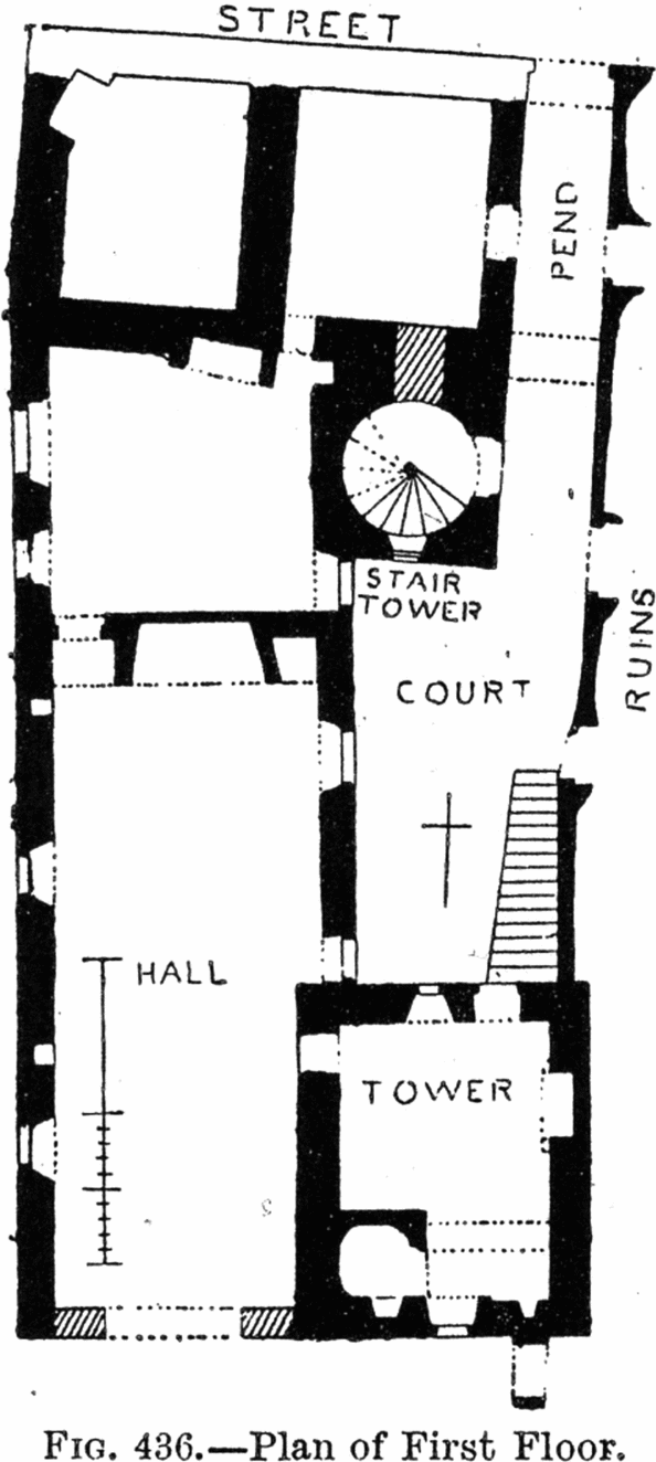
Undivided broad plots of one and a half or more units width provided even more freedom to extend. Good surviving examples of large backland buildings are to be found in Riddle's Court Lawnmarket, Edinburgh, where the late sixteenth-century MacMorran residence fits comfortably into a 2.5-unit plot, as does Acheson House, Canongate, begun in 1633.Footnote 52 In its last phase prior to demolition in 1885, the former town house of the Knights Hospitaller in LinlithgowFootnote 53 presented a two-unit, 11.6-metres wide frontage to the street and incorporated an entry pend and courtyard, which extended back some 26 metres, thus occupying both foreland and backland spaces (Figure 10). Table 2 sets out the plots and unit widths of these few specimen broad plot buildings. Surveyed measurements in the second and third columns are given in metres, and the unit widths are average numbers so do not have full accuracy. This accounts for the plot widths in the table not being at the ideal quarter sizes.
Table 2 Plots and unit widths of specimen broad plot buildings
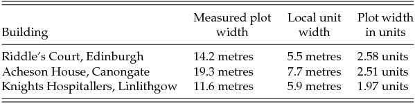
Figure 10: Town house of the Knights Hospitaller, Linlithgow; site plan at first-floor level from David MacGibbon and Thomas Ross, The Castellated and Domestic Architecture of Scotland, vol. I (Edinburgh, 1887), 508, Fig. 436.
As outlined above, the local Dean of Guild Courts had gradually been assuming greater powers to authorize changes, some of which included the crossing of the old plot boundaries that had been set out and safeguarded by the medieval liners. In Edinburgh from the 1670s onwards, they permitted a succession of large-scale redevelopments, such as the erstwhile Robertson's Land (1674) and Milne's Square (1684), together with the still-surviving Milne's Court (1690) and James Court (1723–27), all of which extended across several plots.Footnote 54 Among many later and smaller-scale lateral developments were the two eastward extensions of Gladstone's Land which were built by 1755 following the demolition of earlier properties.Footnote 55 In Stirling, on the other hand, annexation of adjacent plots appears to have had a longer history; there, exceptionally perhaps, several contiguous property units which had first been amalgamated around 1580 were eventually consolidated with others to form the site of the expansive Argyll's Lodging of the 1670s.Footnote 56
Conclusions and comparisons
Relying on the survival of much evidence of Scottish medieval town layouts, particularly among the first Ordnance Survey Town Plans of the 1850s, this article has shown that, despite all the pressures on urban centres, especially Edinburgh’s, long-lasting plot patterns persisted with little change until the last quarter of the seventeenth century and that in the same period street frontage extensions were generally limited to just 7 feet (2.13 metres). Even today, as archaeological and documentary evidence has shown, a high proportion of plot boundaries and street frontage lines remain very close to their original positions on plan.
One inference to be drawn from this conclusion is that the preservation of these urban layouts may in large measure be a reflection of the regulatory effectiveness of the Scottish medieval liners and their successors, the Dean of Guild Courts. Another is that the relative stability of the plot pattern appears to have had an influence on Scottish ‘streetscapes’ and their architectural character that has, to date, been either unacknowledged or at best understated. Land plots are only one of a number of features that have conditioned the urban physical environment, and, while it would be a mistake to regard them as precise or even primary determinants of all urban built forms, building historians and architectural investigators should share the same awareness of their potential significance that archaeologists and historical geographers have long demonstrated.Footnote 57
Focused on the evidence from Scotland and adjacent parts of northern England, this article does not pretend to be an exhaustive and geographically widespread exploration of themes that are potentially as international as urban civilization itself. How far Scottish practices and patterns were unusual or commonplace elsewhere are questions about which, at this stage, the authors can offer only impressionistic comments rather than detailed comparisons and contrasts.
A relatively cursory review of the European urban scene, for example, suggests that a similar, though not necessarily identical, role to that of the Scottish liner appears to have been provided by early land surveyors such as the Flemish landmeter.Footnote 58 Identification and possibly demarcation of plot boundaries appears also to have been an occasional part of the function of the ‘viewers’ of late medieval London and Bristol, who usually served in groups as certificate-issuing witnesses in support of the assize courts.Footnote 59
The authors are not in a position to summarize decades of research into land plots and plot patterns in English and Welsh towns and cities, but from the available secondary literature they gain the impression that medieval and early modern urban layouts there, both formal and informal, tended to be regulated with a greater degree of flexibility than their Scottish counterparts.Footnote 60 These trends appear to be evidenced, for example, by the subdivisions of plots and by the outward extension of building frontages causing congestion within the correspondingly narrower streets and market places upon which they encroached.Footnote 61 It would be a mistake, however, to draw too sharp a contrast with the Scottish morphological evidence.
Individually or in groups, a number of surviving English urban buildings are of special comparative interest in helping to understand how private premises and public spaces may have interacted in Scotland along medieval street fronts. A medieval merchant's house in French Street, Southampton, is a noteworthy surviving example of a timber-colonnaded frontage with a forecourt, while the remarkable Rows of Chester demonstrate unequivocally that raised and covered walkways set on stone-vaulted cellars have a long history in these islands going back to the thirteenth century. Like The Pentice, High Street, Winchester, they help us to visualize Scotland's later and now-vanished ‘wooden piazzas’ and other forms of frontage which served as an interface between private property and public access.Footnote 62