


1. INTRODUCTION
Pseudolites can be used in practice for three main purposes depending on the operational conditions and the user's requirements (Lee et al., Reference Lee, Wang, Rizos and Grejner-Brzezinska2004; Wang, Reference Wang2002):
• To strengthen the geometry of the ranging intersection: when very high accuracy is required, as in deformation monitoring,
• To improve the reliability of a satellite solution: when there are very strict demands concerning the system used, as in aircraft landing,
• To provide the possibility of satellite-like positioning indoors: as in positioning in mines, tunnels, large buildings, etc.
There are a few things to be considered before including a pseudolite in a positioning system. Items of major importance (Cobb, Reference Cobb1997; Wang et al., Reference Wang, Wang, Sinclair, Watts and Lee2005) are:
• Near/far problem.
• Carrier phase noise.
• Multipath.
• Dealing with the navigation message.
• Linearization of observations.
• Modelling of the troposphere.
Some of these issues can be resolved by software modification and some require modification of hardware or both software and hardware. The processing of GPS/pseudolite integrated observations requires a slightly different approach than that taken to standard GPS observables. Factors which need to be taken into consideration in the software are:
• Different troposphere modelling.
• Lack of ionosphere delay in pseudolite observations.
• The necessity of using more than one term of a Taylor series expansion during linearization of observation equations (Cellmer and Rapinski, Reference Cellmer and Rapinski2010), a different method of providing a transmitter's position.
The last point is the main topic of this paper. The method of designing a pseudolite's navigation message is one of the major issues in integrated GPS-pseudolite surveys. The standard algorithm for determination of a satellite position implemented in the receivers does not allow the use of a pseudolite signal. The satellite position is calculated on the basis of Kepplerian orbit parameters, which are not applicable for the pseudolite. In the case of a pseudolite, its position needs to be delivered as fixed coordinates. One solution would be to provide the pseudolite's position by putting the coordinates in spare fields of a navigation data message. This approach would require a modification in a receiver's firmware.
Standard receivers do not use spare fields, so it would not be able to read a pseudolite's position. Another solution would be to elaborate a method which would provide a pseudolite's position without modifying a receiver's firmware. Such a method would be an optimal approach. This paper presents a proposed solution to this problem.
2. SATELLITE POSITION CALCULATION ALGORITHM
To calculate the user's position, each receiver needs to calculate the position of each satellite. It is usually done on the basis of a navigation message sent by a satellite. According to Strang and Borre (Reference Strang and Borre1997), the position of each satellite is calculated using the algorithm presented below:
where ‘a’ is the semi-major axis of the satellite orbit, and:
where:
tk is the time elapsed since toe.
‘t’ is the transmit time.
toe is the ephemeris epoch.

where:
‘M’ is the mean anomaly at time tk
GM=3·986005·1014m3/s2.
Δn and μ0 are obtained from ephemeris data.
Next, the eccentric anomaly ‘E’ is calculated through iteration as:
where:
ecc is the eccentricity of the satellite orbit.
In the first iteration E=M is assumed.
The true anomaly ‘v’ can be calculated using the following equation:

A new variable Φ is introduced and its value is computed using ω from the ephemeris data:
The argument of perigee is computed from:
where Cuc and Cus are obtained from ephemeris data.
Radial distance reads:
where Crc and Crs are also obtained from ephemeris data.
Inclination is calculated from:
Right ascension of ascending node:
Denoting:
and:
The position of a satellite can be expressed in the form of the following vector:
Parameters: μ0, Δn, e, ![]() , Ω0, i0, ω,
, Ω0, i0, ω, ![]() , idot, Cuc, Cus, Crc, Crs, Cic, Cis, toe are broadcast in the ephemerides.
, idot, Cuc, Cus, Crc, Crs, Cic, Cis, toe are broadcast in the ephemerides.
3. MODIFICATION IN THE EPHEMERIS DATA
The position of a pseudolite on the surface of Earth means that there are no valid orbit parameters to describe it (the geostationary orbit at any longitude, latitude and height close to the surface is impossible from a Kepplerian orbit point of view). However, since the algorithm for satellite position computation is well-known, it is possible to express any coordinates using only broadcast ephemerides' data. In this way we can ‘cheat’ the receiver to use the pseudolite just like any other satellite without any modifications. The main goal of the algorithm presented below is to make the resulting coordinates independent from time and fix them at required values.
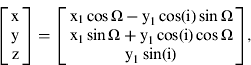
Let us denote a known pseudolite's coordinates as X, Y, Z in an Earth-fixed, Earth-centred coordinate system. All three coordinates depend on Ω, i, x1, y1 where both ‘x1’ and ‘y1’ depend on ‘u’ and ‘r’. First, let's make the assumption that ![]() and substitute Equations (11) and (12) into Equation (13):
and substitute Equations (11) and (12) into Equation (13):

where ‘x, y, z’ are known pseudolite coordinates.
For the ‘u’ parameter to be set to ![]() the following conditions must be fulfilled:
the following conditions must be fulfilled:
• In Equation 7 terms Cuc, Cus must be set to 0.
• In Equation 6 parameter v must be set to 0.
• Parameter ω must be set to
 .
.• For the ‘v’ to be 0 parameter ecc must be set to 0 and parameter Δn must be set to:
(15)• Parameter a in the above equation must be set to r.
From the set of Equation(s) 14, the values of Ω, ‘I’ and ‘r’ can be derived:
To make Ω independent from time, the parameter toe must be equal to 0 and ![]() must be equal to 7·2921151467·10−5, which is equal to the Earth's rotation rate. Similarly, to make ‘i’ independent from time, the parameters idot, Cic, Cis must be set to 0. The value from Equation 16 for Ω0 and the value from Equation 16 for i0 must be substituted in the ephemeris data. Parameter ‘r’ must be treated in an analogous way. Crc, Crs, eccmust be equal to 0. Then r=a which can be substituted into the ephemeris data. The summary of modifications made to the ephemeris data to obtain the pseudolite location is presented in Table 1.
must be equal to 7·2921151467·10−5, which is equal to the Earth's rotation rate. Similarly, to make ‘i’ independent from time, the parameters idot, Cic, Cis must be set to 0. The value from Equation 16 for Ω0 and the value from Equation 16 for i0 must be substituted in the ephemeris data. Parameter ‘r’ must be treated in an analogous way. Crc, Crs, eccmust be equal to 0. Then r=a which can be substituted into the ephemeris data. The summary of modifications made to the ephemeris data to obtain the pseudolite location is presented in Table 1.
Table 1: Ephemeris data modification.

4. EXAMPLE
In order to test the developed algorithm, real data was used. One of the possible ways of dealing with pseudolite signal identification is to use the Pseudorandom Noise (PRN) code number of a satellite that is not in view (Bond, Reference Bond2007). Table 3 presents standard and modified parameters along with resulting coordinates. The true pseudolite coordinates are presented in Table 2. The calculations were made for epoch 700 and PRN23. From Table 3 we can see that the final position computed on the basis of original ephemerides is not correct, whereas the position computed from modified ephemerides is correct (computed coordinates are the same as in Table 2).
Table 2: Pseudolite's coordinates.

Table 3: Example of ephemeris data modification.

5. CONCLUSIONS
The algorithm presented above should allow an off-the-shelf receiver to obtain a pseudolite position using only standard navigation message format. It requires only a few simple computations to obtain a proper fixed pseudolite position. Ten parameters from the ephemeris data must be zeroed, a fixed value must be substituted for two parameters and four values must be calculated on the basis of a known pseudolite position. These values will be used to modify the navigation data in a transmitter or in navigation data file for post-processing. Despite the fact that the satellite position computations in a receiver are time-dependent, the algorithm will result in fixed coordinates regardless of the GPS time.


