


Past agrarian-based, low-density urban tropical societies in the western and eastern hemispheres faced significant climatic challenges. These included: distinct wet and dry seasons; tropical storms or monsoons with torrential downpours; hurricanes or typhoons; variable water quality; prolonged droughts; and rainfall-dependency. In southern Asia, Southeast Asia and the southern Maya lowlands (south-east Mexico, Belize and northern Guatemala) between the ninth and sixteenth centuries AD, the primary, low-density urban centres broke down. This process was largely triggered by long periods of climate instability, defined here as the magnitude of seasonal weather pattern changes that persistently interfered with the food and water supplies necessary to support growing populations and infrastructure systems. Particularly critical was the impact of this instability on large-scale water management, which formed one of the key foundations of political power by providing the means to integrate dispersed subjects. Political dynasties fell or transformed, with some relocating to adjacent regions, while the farmers who supported those dynasties endured, retaining sustainable agricultural practices, albeit reconfigured across the landscape. The low-density dispersed urban landscape faded away and the urban world re-created itself in a more compact form in new locations and regions along the peripheries. This movement across the landscape we term urban diaspora, when people abandon not only the urban centres but much of the metropolitan heartland and move to peripheral areas where different kinds of networks and economic and political foci emerge.
Pre-industrial, agrarian-based, low-density urban societies in tropical settings were situated between the centripetal pull of political centres and the centrifugal forces of agricultural demands. We illustrate here how water management, political infrastructure, sustainable agricultural practices and climate change were implicated in the urban diaspora of three tropical societies. In each region, despite differences in politics, social organisation, water control and economic basis, the consistent outcome was a move to the regional periphery, indicating that a broad operational process was involved (see Fletcher Reference Fletcher, Schofield, Johnson and Beck2002, Reference Fletcher and Bintliff2004, Reference Fletcher, Hicks and Beaudry2010). One of our key points is that while socio-political systems varied, it was the impact of climate change on the infrastructure that generated destabilisation; this played out in a variety of ways in different social systems. Urban diaspora was not a post-collapse state of being but rather a behavioural adjustment to long-term climate instability by low-density urban societies.
Low-density urbanism in the tropics
Tropical areas are notable not only for their seasonal vagaries, but also for their dispersed and varied biodiversity that is mirrored in settlement patterns and people's reliance on a mosaic of adaptive strategies (Fletcher Reference Fletcher2009, Reference Fletcher and Smith2012; Scarborough & Burnside Reference Scarborough and Burnside2010). People increasingly transformed the landscape, especially through small-scale hydraulic and agricultural features, without much political interference (Hawken Reference Hawken2007; Scarborough & Lucero Reference Scarborough and Lucero2010; Gilliland et al. Reference Gilliland, Simpson, Adderley, Burbidge, Cresswell, Sanderson, Coningham, Manuel, Strickland, Gunawardhana and Adikari2013). Farmers worked together to build and maintain subsistence features (e.g. Lansing Reference Lansing1991, Reference Lansing2006; McIntosh Reference McIntosh2005). Political hierarchies emerged in developing urban cores for other reasons, in exchange for tribute—supplying capital, protection and organising the infrastructure that provided water for drinking and agriculture and controlled flooding (Coningham Reference Coningham1999; Lucero Reference Lucero2006; Coningham et al. Reference Coningham, Gunawardhana, Manuel, Adikari, Katugampola, Young, Schmidt, Krishnan, Simpson, McDonnell and Batt2007; Fletcher et al. Reference Fletcher, Penny, Evans, Pottier, Barbetti, Kummu and Lustig2008). Cities came to integrate thousands of people socially and politically, and they provided places for markets, exchange and religious institutions, and for elites to display their wealth and power (Lucero Reference Lucero2003, Reference Lucero2007; Coningham & Gunawardhana Reference Coningham and Gunawardhana2013). While people, ideas, goods and information flowed in and out of central places, mobility was scheduled around seasonal agricultural regimes.
In low-density cities, agricultural and open land is interwoven with massive urban infrastructure and a dispersed residential population (Graham Reference Graham, Bacus and Lucero1999). The urban-rural population was simultaneously agriculturally based and civically integrated (e.g. Pottier Reference Pottier2000; Fletcher Reference Fletcher and Smith2012; Isendahl Reference Isendahl2012). The rural world was therefore interdigitated and entangled with the urban world through an extensive, varied crop economy based on profitable trees, swidden (slash and burn) agriculture and engineered fields, and an urban-based water management infrastructure. The central areas of low-density cities are centripetal because they draw people in via political, social, economic and religious means. The surrounding areas are centrifugal because people settle across the landscape in farmsteads and villages mirroring the dispersed agricultural and natural resources interspersed with managed forests and grazing land. Farmers relied on flexible subsistence strategies involving local small-scale production and exchange, and water and agricultural systems. The populace supplied staples, local goods, labour and services (e.g. maintaining transportation routes) via tribute and exchange, effectively funding the political economy. People became beholden to a centralised political elite for access to water via central reservoirs during annual drought. In the agricultural (rainy) season, farmers worked their fields throughout the non-urban landscape.
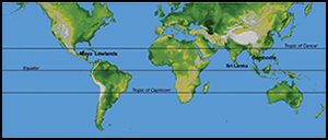
In the southern Maya lowlands, Sri Lanka and mainland Southeast Asia, the agrarian-based dispersed cities varied considerably in size. The largest Maya centres covered around 100–200km2, while Anuradhapura and Angkor were between about 500 and 1000km2 in extent. The South Asian examples were also distinct primate cities in their regions, in contrast to the Maya region with its multitude of centres and kings. Rice was the main staple for the Khmer and Sinhalese, while the Maya relied on maize; the Maya also differ in that they did not have metal tools, beasts of burden, major road systems or access to an extensive international maritime trade network. To retain as much consistency of comparison as possible, our study addresses the largest examples in each region: the Khmer capital of Angkor in Cambodia (ninth–sixteenth century), the Sinhalese capital of Anuradhapura in Sri Lanka (fourth century BC–eleventh century AD), and the major Maya capital of Tikal in Guatemala (sixth–tenth century AD) (Figure 1). The central areas of these cities encompassed palaces, temples, causeways, reservoirs, plazas, elite residences and markets, illustrating their role in attracting and integrating rural subjects. About 750 000 people lived dispersed over the 1000km2 of Greater Angkor between the twelfth and thirteenth centuries (Fletcher et al. Reference Fletcher, Barbetti, Evans, Than, Sokrithy, Chan, Penny, Pottier and Somaneath2003; Evans et al. Reference Evans, Pottier, Fletcher, Hensley, Tapley, Milne and Barbetti2007; Coe Reference Coe, Guadalupe, Cobean, Garcia and Hirth2008). There may have been as many as 250000 people in and around Anuradhapura (Coningham & Manuel Reference Coningham, Manuel and Harrison2009), and perhaps as many as 60 000 in the immediate environs of Tikal (Culbert & Rice Reference Culbert and Rice1990).

Figure 1. Tropical zone and areas mentioned in text; generated by L.J. Lucero using a map courtesy of NASA/JPL/NIMA; available at: http://photojournal.jpl.nasa.gov/catalog/PIA03395 (accessed 29 April 2015).
The focal role of the central areas is illustrated by the capacity of the courtyards of the three great monasteries of Anuradhapura to accommodate 30000 pilgrims, while their individual stone rice containers could have fed over 1000 monks at each sitting (Coningham & Gunawardhana Reference Coningham and Gunawardhana2013). In Angkor, the late twelfth-century temple of Ta Prohm had a staff of 12640 living nearby supported by 66625 farmers (Kapur & Sahai Reference Kapur and Sahai2007: 52–56). At Tikal urban plazas could hold over 10500 people (Inomata Reference Inomata2006: tab. 1), who participated in royal ceremonies and feasts with foodstuffs presumably supplied by subjects and from royal reserves (Masson & Freidel Reference Masson and Freidel2012). All three low-density urban societies encompassed immense urban water systems that served as the core for the political economy; this focus is critical in understanding the increasing complexity of engineered landscapes and concomitant political vulnerability. While some factors are unique to the tropics, any political system is vulnerable when intertwined to the extent where changing conditions affecting one link can have major repercussions throughout the system.
Water management in the tropics: seasonal ebb and flow
Water is the essential element of life, hydrating people, watering fields and serving as a vital component in the manufacture of ceramics, plaster, cement and bricks. Controlling water is necessary; accessing it is another matter entirely and depends on several factors including seasonality, amount, intensity and timing. Seasonal rainfall is critical in tropical areas and affects all aspects of society. In such rainfall-dependent societies, predicting when the rains will begin is crucial for agricultural scheduling and replenishing reservoirs (Scarborough Reference Scarborough2003). Humidity and seasonality intensify the threat of agricultural pests and waterborne diseases unless agricultural and water-management strategies are coordinated (Lansing Reference Lansing1991; Miksic Reference Miksic, Bacus and Lucero1999). Water thus needs to be contained and distributed in the rainy season, conserved in the dry season and allocated throughout the year. Rulers ensured functioning water systems through varying modes and degrees of control in return for subjects’ goods, labour and services. That said, long-term and drastic climate change, which can result in flooding and prolonged droughts, disrupts planning and management, schedules and mobility flows to and from centres (Lucero Reference Lucero2002; Buckley et al. Reference Buckley, Fletcher, Wang, Zottoli and Pottier2014).
Rural communities maintained local small-scale water systems, and in due course the populace maintained the state-managed urban ones (Brohier Reference Brohier1934; Leach Reference Leach1959). Initially, water features required centralised management to engineer and build. Once in place, however, a large labour force replaced technological skill to expand and maintain them (Scarborough & Burnside Reference Scarborough and Burnside2010). Reservoirs supplied water for food production and in the long dry season drew in the dispersed farmers who needed access to potable and distributable water. As water systems increased in scale and complexity, reservoirs and associated channels and roads increasingly affected urban layout and assimilated people. Water features were built next to temples and palaces, but also comprised a part of the cosmological landscape by recreating primordial waters central to their origin stories. This tripartite arrangement literally and figuratively represented the close connection between water, power and cosmology.
Angkor is famous for its sophisticated and massive baray (artificial reservoirs), such as the West Baray (16km2 of water enclosed by over 15 million cubic metres of embankment) located near the central palaces and temples. The Khmer built the two largest baray between the ninth and eleventh centuries, measuring approximately 7–8 × 2km and 2–5m deep (Fletcher et al. Reference Fletcher, Penny, Evans, Pottier, Barbetti, Kummu and Lustig2008) (Figure 2). They were filled and drained using a complex system of canals that extended for hundreds of kilometres (Evans et al. Reference Evans, Fletcher, Pottier, Chevance, Soutif, Tan, Im, Tin, Kim, Cromarty, de Greef, Hanus, Bâty, Kuszinger, Shimoda and Boornazian2013). Baray were the central units of a tripartite system that spread water out over the northern part of Angkor, channelled it into baray and sent some out of the eastern exit channels into the southern canals (Kummu Reference Kummu2009). The system served two main functions: canals flowing south-south-west to the great lake, Tonle Sap, acted as drains to dispose of water, while canals flowing south-south-east allowed the distribution of water downslope across the richer rice-producing lands near the lake, assisting the growth of the relatively high-yield rice by ensuring the supply of water at the critical start and end of the growing season. As the annual rainfall of 1500mm largely falls between May and October, rice production was especially vulnerable to early and late season vagaries. Supplying water by successively skimming and reloading the baray created a risk-management mechanism for ensuring stable crop supplies to cover potential shortfalls of rice for about 100000 to 200000 people (Fletcher et al. Reference Fletcher, Barbetti, Evans, Than, Sokrithy, Chan, Penny, Pottier and Somaneath2003).

Figure 2. Angkor water systems; the close-up shows temple complexes and moats and reservoirs (rectangular, flat); generated by D. Brotherson; courtesy of APSARA, D. Evans and C. Pottier; LiDAR image courtesy of KALC and NASA Shuttle Radar Topography Mission.
Anuradhapura is located in the Dry Zone of Sri Lanka with an annual rainfall from 1300–1450mm between December and February (Figure 3). With a carrying capacity of 0.4 individuals per km2 and largely seasonal water sources (Coningham Reference Coningham1999), it was necessary to store water during the dry season. The construction of reservoirs near the city started in the fourth century BC. At the same time, independent cascade systems were constructed in the hinterland (Coningham & Gunawardhana Reference Coningham and Gunawardhana2013). People relied on irrigated rice as a staple, augmented by kitchen gardens and swidden cultivation known as chena (Coningham Reference Coningham2006). As the central area and its ring of Buddhist monasteries expanded, so did the capacity of its reservoirs with the construction of the Tissawewa (5.5km2) in the third century BC and Nuwarawewa (9km2) in the first century AD. By the fifth century, increasing demand led to the building of timber and stone annicuts (dams) and the cutting of feeder canals, such as the 87km-long Jaya Ganga and Yoda Ela, which linked major reservoirs to more reliable sources in the hill country via storage reservoirs such as the Kalawewa (25.8km2) and Nachchaduwawewa (17.8km2). This arrangement mirrored the social and political hierarchy whereby the upper tiers were maintained and managed by the elites, and individual cascades were maintained by local communities and monasteries.

Figure 3. Anuradhapura, Sri Lanka, showing settlement and water systems during the Early Medieval Period; generated by M. Manuel.
The most powerful Classic Maya centres in the southern Maya lowlands, such as Tikal and Naranjo in Guatemala and Calakmul in Mexico, are located in areas with some of the best tropical soils for maize agriculture but little or no surface water (Fedick Reference Fedick and Fedick1996). The rich soils are dispersed in variously sized pockets that correlate with settlement density and political power in a managed forest landscape (Ford & Nigh Reference Ford and Nigh2009). There were hundreds of centres, each with their own king; the degree of power and number of subjects varied dramatically and was based largely on the amount and distribution of fertile agricultural soils, means of water containment and access to trade routes (Lucero Reference Lucero2006). Annual rainfall varies regionally and ranges from 1350–3700mm between July and December. Much of this is absorbed by the permeable karst landscape, making its capture and storage essential (Scarborough Reference Scarborough1993). The Maya began constructing reservoirs c. 100 BC with passive or concave micro-watershed systems where water was diverted by gravity downslope and stored, as seen at El Mirador and Nakbe in Guatemala (Scarborough & Gallopin Reference Scarborough and Gallopin1991). The Maya abandoned these centres by AD 150, probably as a result of silting problems, forest mismanagement and climate instability. Between c. AD 550 and 850, the Maya engineered large-scale water systems—convex micro-watershed systems built upslope on hilltops and ridges that comprised reservoirs, dams and channels. Excavations of reservoirs at Tikal also show that the Maya used sluices, filtration systems and switching stations (Scarborough et al. Reference Scarborough, Dunning, Tankersley, Carr, Weaver, Grazioso, Lane, Jones, Buttles, Valdez and Lentz2012) (Figure 4). Water features were distributed across the urban layout. Processional roadways (sacbeob) connected religious or residential compounds and also served as dams and diversionary devices. There were also terraces, as seen at the regional capital of Caracol, where soils are less fertile (Chase et al. Reference Chase, Chase, Weishampel, Drake, Shrestha, Slatton, Awe and Carter2011).

Figure 4. Maya lowland water systems and settlement; centre image shows reservoirs and catchment areas in Tikal; blue lines signify major arroyos (500 × 500m squares) (generated by C. Carr in Scarborough et al. Reference Scarborough, Dunning, Tankersley, Carr, Weaver, Grazioso, Lane, Jones, Buttles, Valdez and Lentz2012: fig. 1, courtesy of V. Scarborough). Lower right image illustrates dispersed settlement on hilltops, terraces and reservoirs (depressions) at Caracol, Belize (Chase et al. Reference Chase, Chase, Weishampel, Drake, Shrestha, Slatton, Awe and Carter2011: fig. 6, used with permission of the UCF Caracol Archaeological Project). Maya map generated by L.J. Lucero courtesy of NASA/JPL/NIMA. Available at: http://photojournal.jpl.nasa.gov/catalog/PIA03364 (accessed 29 April 2015).
Maintaining water quality is a necessary but challenging feat in the humid tropics where standing water provides prime conditions for the build-up of noxious elements (e.g. nitrogen) and the proliferation of water-borne parasites and diseases (e.g. hepatic schistosomiasis, cholera and so on) (Burton et al. Reference Burton, King, Ball and Baker1979). The Maya maintained water quality by selecting certain hydrophytic and macrophytic plants to transform artificial reservoirs into constructed wetland biospheres (Lucero et al. Reference Lucero, Gunn and Scarborough2011). The presence of Nymphaea ampla indicates clean water. This sensitive water lily proliferates on reservoir surfaces and was common in royal iconography and inscriptions, signifying the close relationship between kingship and water management (Lucero Reference Lucero, Bacus and Lucero1999). A similar situation existed in South Asia where the lotus (Nelumbo nucifera) symbolised creativity and represented the potential of all beings to rise above suffering and embrace purity (McArthur Reference McArthur2002). As long as kings provided potable water and maintained other integrative facilities and events, subjects remained loyal and political security remained intact.
A distinct feature of these tropical societies is their growing reliance on increasingly elaborate, complex and intricately linked water systems. Dependency on these systems could continue so long as external circumstances did not change. But they did change, via climatic instability in each area at various times, severely weakening water networks to the extent that they eventually failed. As a consequence, people from all walks of life left the dispersed urban landscape and its central nodes in search of more reliable sources of water and economic opportunities.
Climate instability and the urban diaspora
While it is relatively common for political systems to fluctuate in scale and place (e.g. building new capitals, replacing dynasties), something in these tropical cases resulted in the inhabitants largely abandoning not only the urban centres but also much of the metropolitan heartland. Former subjects continued farming, but many did so in different areas within smaller community networks and engaged in a different kind of urbanism on the periphery of the former states. The dispersal involved the disjunction between five major components: the urban hierarchical political system; substantial infrastructure; urban-rural integration; diverse farming practices; and climate change.
Severe climatic instability from the ninth to eleventh centuries (increasing temperatures and prolonged droughts) and the fourteenth to sixteenth centuries (decreasing temperatures and increasingly severe wet periods and droughts) strained embedded water systems. Analysis of annual ring growth of speleothems from caves and from trees provides a detailed history of long-term weather patterns, as do sediment core data from lakes and reservoirs (e.g. Penny et al. Reference Penny, Pottier, Fletcher, Barbetti, Fink and Hua2006, Reference Penny, Pottier, Kummu, Fletcher, Zoppi, Barbetti and Tous2007; McNeil et al. Reference McNeil, Burney and Burney2010; Medina-Elizalde et al. Reference Medina-Elizalde, Burns, Lea, Asmerom, von Gunten, Polyak, Vuille and Karmalkar2010; Mueller et al. Reference Mueller, Islebe, Hillesheim, Grzesik, Anselmetti, Ariztegui, Brenner, Curtis, Hodell and Venz2010; Day et al. Reference Day, Hodell, Brenner, Chapman, Curtis, Kenney, Kolata and Peterson2012). We can now relate these to social histories (e.g. Scheffran Reference Scheffran2008; Buckley et al. Reference Buckley, Anchukaitis, Penny, Fletcher, Cook, Sanod, Nam, Wichienkeeo, Minh and Hong2010, Reference Buckley, Fletcher, Wang, Zottoli and Pottier2014; Zhang et al. Reference Zhang, Lee, Wang, Li, Pei and Zhang2011; Lieberman & Buckley Reference Lieberman and Buckley2012; Lucero et al. Reference Lucero, Gunn, Scarborough, Chase and Scarborough2014).
The relationship between climate change and societal transformation is complex and multidimensional (e.g. Turner & Sabloff Reference Turner and Sabloff2012; Iannone Reference Iannone2014). The demise of dispersed urbanism in each region was a unique sequence of events, yet led to a similar outcome—urban diaspora. For Angkor, climate change came in the form of “protracted periods of drought and deluge rain events” (Buckley et al. Reference Buckley, Fletcher, Wang, Zottoli and Pottier2014: 1); this interpretation is based on tree-ring data (Buckley et al. Reference Buckley, Anchukaitis, Penny, Fletcher, Cook, Sanod, Nam, Wichienkeeo, Minh and Hong2010). In this diaspora, much of the residential population disappeared from Angkor and its vicinity and established small towns in a wide arc from Battambang along the southern side of the Tonle Sap, along and up the Mekong River (Figure 5), and in a great arc through Isan far to the north. Khmer elites moved towards the Phnom Penh region, initially migrating between multiple capitals (Thompson Reference Thompson, Marston and Guthrie2004: 33). By the sixteenth century the centre of royal power had shifted to the Phnom Penh area (Groslier Reference Groslier2006: 118–20). In the late nineteenth century only eight small villages existed in central Angkor (de Lajonquière Reference Lajonquière1911).

Figure 5. Urban diaspora in three tropical regions (red–black dots); generated by D. Brotherson.
In Sri Lanka settlement decreased within a radius of 15km in central Anuradhapura from a peak of 292 sites in the Early Medieval period to only 11 by the eleventh century (Coningham & Gunawardhana Reference Coningham and Gunawardhana2013). This decline was paralleled by the abandonment of the urban core and most monasteries in the central and outer areas. The extended network of reservoirs and canals suffered breaches and silted up due to lack of maintenance (Brohier Reference Brohier1934 Part II: 8). The area was not entirely abandoned, as small communities still practised swidden cultivation prior to the nineteenth-century recolonisation of the Dry Zone (Gilliland et al. Reference Gilliland, Simpson, Adderley, Burbidge, Cresswell, Sanderson, Coningham, Manuel, Strickland, Gunawardhana and Adikari2013). The silting and abandonment appear to have been accompanied by a corresponding sudden high-amplitude increase of the South West Monsoon, which would have resulted in both severe drought and an increase in cyclonic storms within the North East Monsoon (Jung et al. Reference Jung, Davies, Ganssen and Kroon2004). The decline of Anuradhapura is linked with the later growth and expansion of its successor, Polonnaruwa. That city was also abandoned in the thirteenth century, but not before its leaders constructed the immense ‘Sea of King Parakramabahu’ covering 87km2 (Gilliland et al. Reference Gilliland, Simpson, Adderley, Burbidge, Cresswell, Sanderson, Coningham, Manuel, Strickland, Gunawardhana and Adikari2013). The court then shifted southwards through the compact capitals of Dambadeniya and Kurunagala, and then up into the hill country and the Wet Zone, eventually basing the capital at Kandy (Coningham Reference Coningham1999), while towns increasingly began to concentrate along the coast (see Figure 5). The destabilising of Anuradhapura corresponds with the increasing temperatures of the eleventh and twelfth centuries; the later shifts correlate closely with severely reduced monsoon rainfall over a multi-decadal period between the fourteenth and fifteenth centuries, as indicated by oxygen isotope analysis of a stalagmite from a cave in east-central India (Sinha et al. Reference Sinha, Cannariato, Stott, Cheng, Edwards, Yadava, Ramesh and Singh2007).
In the Maya area, speleothem data from a cave in north-west Yucatán, Mexico, show that at least eight prolonged droughts struck between c. 800 and 930 AD. These droughts negatively affected reservoir systems (Medina-Elizalde et al. Reference Medina-Elizalde, Burns, Lea, Asmerom, von Gunten, Polyak, Vuille and Karmalkar2010) and exacerbated existing problems, including population growth, overuse of resources and erosion caused by deforestation (Lucero et al. Reference Lucero, Gunn and Scarborough2011; Dunning et al. Reference Dunning, Beach and Luzzadder-Beach2012). During these tumultuous times, not only did kings at smaller centres challenge political powers on the battlefield, as recorded in inscriptions, but royal subordinates also began to appear in the iconography alongside their kings (e.g. Yaxchilán, Copán and Piedras Negras) and to co-opt royal symbols for their own use (e.g. Copán; Fash Reference Fash, Andrews and Fash2005) (Martin & Grube Reference Martin and Grube2008). In the AD 800s, Maya farmers withdrew their support from kings who no longer fulfilled their obligation as water managers and subsequently abandoned monarchs and centres (Lucero Reference Lucero2002). Kings lost their means of support and abandoned their capitals, relocating elsewhere and either dying out or reverting to what their forebears had been—elite landowners. While rulers lost power, farmers persevered by living in smaller communities or migrating out of the interior nearer to the coasts and along major rivers where market towns and trade flourished (Sabloff Reference Sabloff2007; Graham Reference Graham2011), as seen at Chichén Iztá, Chetumal, Cozumel and Bacalar, among others (Masson & Freidel Reference Masson and Freidel2012) (see Figure 5).
Concluding remarks
Low-density urbanism, extensive and diverse farming, dependence on massive infrastructure, severe climate change and a complex interaction with political systems appear to be the major factors triggering urban diaspora in diverse regions. The intricacy, complexity and magnitude of water management and political power in the southern Maya lowlands, Southern Asia and Southeast Asia had increased in tandem with increasing inflexibility and decreasing diversity, creating greater urban-rural interdependence. While the interlocking systems may initially have coped with changing circumstances, including climate extremes, they eventually failed.
Each society played out a unique history due to its internal characteristics, but urban diaspora was the consistent outcome. We know that people from all walks of life abandoned the former urban centres and their environs, drastically reducing the populations of the metropolitan heartlands. Rulers either moved away and adapted by creating new political institutions (Khmer, Sinhalese), or disappeared altogether (Maya of the southern lowlands), while most of their subjects survived by continuing to farm and by shifting location to participate in new urban networks. As these cases show, political collapse does not equate with societal collapse (see Lucero Reference Lucero2006: 24–25; McAnany & Yoffee Reference McAnany and Yoffee2009; Middleton Reference Middleton2012). Indeed, the area beyond the central Buddhist shrines of Anuradhapura displayed a growth in non-Buddhist cults and ritual practices close to dwindling reservoirs. At Angkor, areas of bunded rice fields were in use to the south of the East and West Baray in the nineteenth century, and swidden still occurred on dry upland slopes, as it did in the Dry Zone of Sri Lanka. Maya farmers still worked their dispersed fields near permanent water sources, such as Lake Petén Iztá in Guatemala and the Belize River in Belize.
In the end, the different histories of kings and farmers relate to the different constructs in which they existed: inflexible vs flexible strategies; a reliance on massive vs small-scale diverse water systems; and entrenched and rigid vs resilient and adaptable systems. Although noticeable cultural differences and specific political pathways existed among these tropical societies amidst the waxing and waning of political histories and sustainable agricultural practices, the significant overall similarity is the trajectory of urban diaspora. The combination of dependence on massive infrastructure, low-density urbanism and severe climate change has some resonance in the present day, a topic that we plan to examine in the future.
Acknowledgements
We are grateful to the participants in the ‘Low-Density Urbanism, Water Management, and Sustainability in the Tropics’ July 2012 conference in Siem Reap, Cambodia, for discussion of this topic (funded by Wenner-Gren Foundation, #CONF-594, awarded to Lucero and Fletcher), and for private donations. Thanks also go to Patricia McAnany for discussions on human diaspora. We are also deeply grateful to our respective research teams for all their contributions over many years.


